
Borculo
 flag |
 coat of arms |
| province |
|
| local community |
|
|
Area - land - water |
55.9 km 2 55.02 km 2 0.88 km 2 |
| Residents | 10,540 (Jan. 1, 2017) |
| Coordinates | 52 ° 7 ' N , 6 ° 31' E |
| Important traffic route |
|
| prefix | 0545 |
| Postcodes | 7241, 7244, 7261, 7271 |
 |
|
 |
|
Borculo ( Low German Borklo , older spellings: "Borkelo" and "Borkulo") is a Dutch city in the Achterhoek in the province of Gelderland . The city on the Berkel owes its name to the lordship and the Kasteel Borculo .
Borculo was an independent municipality until January 1, 2005 , when it was merged with Eibergen , Ruurlo and Neede to form today's municipality of Berkelland .
history
The Lords of Borculo were first mentioned in writing in the 12th century. Around this time, the Borculo Castle and settlement were built. In 1375 Borculo got city rights . Until 1616 Borculo belonged to the diocese of Münster and was Catholic. Then the Reformation was introduced.
photos

Church: de Onze Lieve Vrouw Tenhemelopnemingkerk

Church: de Joriskerk
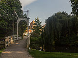
Drawbridge at de Burg. Bloemersstraat


_op_de_achtergrond_foto13_2015-08-22_17.56.jpg)
politics
Distribution of seats in the municipal council
Until the municipality was dissolved, the following distribution of seats had been made since 1990:
| Political party | Seats | |||
|---|---|---|---|---|
| 1990 | 1994 | 1998 | 2002 | |
| VVD | 4th | 4th | 5 | 5 |
| PvdA | 5 | 4th | 5 | 4th |
| CDA | 4th | 3 | 3 | 3 |
| Borculo municipality | 2 | 3 | 2 | 3 |
| D66 | - | 1 | - | - |
| total | 15th | 15th | 15th | 15th |
Web links
Individual evidence
- ↑ Kerncijfers wijken en buurten 2017 Centraal Bureau voor de Statistiek , accessed on July 2, 2018 (Dutch)
- ^ Joannes Henricus Hofman: Het oude kerspel Borkelo . In: Archief voor de geschiedenis van het bisdom Utrecht , Vol. 1 (1874), pp. 179–207, here p. 206.
- ↑ Allocation of seats in the municipal council: 1990–2002 , accessed on July 2, 2018 (Dutch)