
Ruurlo
 flag |
 coat of arms |
| province |
|
| local community |
|
|
Area - land - water |
54.97 km 2 54.73 km 2 0.24 km 2 |
| Residents | 7,820 (Jan. 1, 2017) |
| Coordinates | 52 ° 5 ' N , 6 ° 27' E |
| Important traffic route |
|
| prefix | 0573 |
| Postcodes | 7025, 7136, 7244, 7251, 7255, 7261 |
 |
|
 |
|
Ruurlo ( Low German Reurle ) is a Dutch village in the Achterhoek in the province of Gelderland .
Ruurlo was an independent municipality until January 1, 2005 , when it was merged with Borculo , Eibergen and Neede to form today's municipality of Berkelland .
photos
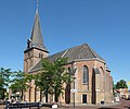
Ruurlo, reformed church
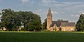
Ruurlo, church: de Sint Willibrorduskerk
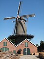
Ruurlo, mill: houtzaagmolen Agneta


politics
Until the municipality was dissolved, the following distribution of seats had been made since 1990:
| Political party | Seats | |||
|---|---|---|---|---|
| 1990 | 1994 | 1998 | 2002 | |
| VVD | 5 | 5 | 5 | 4th |
| CDA | 4th | 3 | 3 | 4th |
| PvdA | 4th | 3 | 3 | 3 |
| Democratic Platform Ruurlo | - | - | 2 | 2 |
| Lijst-Visser | - | 2 | - | - |
| total | 13 | 13 | 13 | 13 |
Community partnerships
In 1979 a partnership was concluded with Fürstenau in Lower Saxony .
Web links
Commons : Ruurlo - collection of images, videos and audio files
Individual evidence
- ↑ Kerncijfers wijken en buurten 2017 Centraal Bureau voor de Statistiek , accessed on July 2, 2018 (Dutch)
- ↑ Allocation of seats in the municipal council: 1990–2002 , accessed on July 2, 2018 (Dutch)
- ↑ Entry on the partnerships of the communities in the joint community of Fürstenau on their homepage.Accessed on May 7, 2019, 3:24 pm