
Burlo Convention
.jpg)
With the signing of the Burlo Convention , a congress ended in 1765 which dealt with the German - Dutch border issue in the area of Westmünsterland and the Achterhoek between Vreden and Eibergen in the north and Dinxperlo and Suderwick in the south.
The name goes back to the border village Burlo on the German side . Here the delegations met in the Mariengarden monastery , which is not far from the border and roughly in the middle of the border section in question. On October 19, 1765, with the signing of the Burlo Convention, the state border between the Duchy of Geldern as a province of the United Netherlands and the Duchy of Münster was finally established. The regulations that were made at that time are essentially still in place today.
prehistory

In the course of the migration of peoples , the Saxons occupied the area east of the IJssel and displaced the Franconian tribes originally resident here , with the Franks in Hamaland being able to claim a strip to the right of the IJssel. Thus, at the transition from Late Antiquity to the Early Middle Ages, an ethnological border developed in what is now the West Munsterland-Dutch border area. This line remained essentially untouched for a long time; it ran through the moor and heather belt to the west and north of Hengelo , Lichtenvoorde , Borculo and Eibergen . Large areas of what is now the Dutch Achterhoek , as part of the Saxon area, were Westphalian at the time . Until the Second World War , the state border in the west of the Ahaus and Borken districts had no significant significance as a dialect divide - a sign of the close neighborly relations that had grown and maintained over centuries.
After Charlemagne had remained victorious in the Saxon Wars and incorporated the tribal duchy of Saxony into his Frankish Empire , he installed Liudger as the first bishop of Münster . Its mission area ended in the west on the border of the former tribal duchy of the Saxons. This border was also the western border of the diocese of Münster , whose original parishes were Winterswijk , Zelhem and Groenlo . The western border of the diocese of Münster ran through what is now Gelderland until 1823, regardless of any changes in territorial affiliation .
At the end of the 12th century, the Duchy of Münster emerged as the dominant power on the German side of today's state border , after the Duchy of the Saxons disintegrated after Henry the Lion was ousted. As a result, a number of smaller territories of formerly independent mansions came under the influence of the Münster prince-bishops, who tried to bring their secular and pastoral domains to coincide.

Thus the rule of Lohn , which stretched across borders from the area around Stadtlohn and Südlohn to Bredevoort , fell to the bishopric in 1316. However, the county of Geldern also made claims on Bredevoort. This dispute, known as the Geldrische or Bredevoorter feud , was only settled ten years later, on June 28, 1326, with the peace treaty of Wesel. It joined Prince Bishop Ludwig II. The castle Bredevoort at the Utrecht Bishop John of service from. The Winterswijk, Dinxperlo and Aalten courts went to Rainald II , Count von Geldern , as a deposit . The deposit worth 3500 marks was never redeemed and so the glory of Bredevoort came under Geldrian influence.
Like Breedevoort, the Borculo rule to the north , a Münster fiefdom since 1406 , became part of the Duchy of Geldern over time. After the death of Joost von Bronckhorst, who had remained childless, in 1553, Bishop Wilhelm Ketteler withdrew the fief and granted Joost's widow Maria von Hoya a lifelong usufructuary right . However, Wilhelm had to deal with Joost's cousin Irmgard zu Limburg-Styrum , who made claims to the glory. A judgment of the Münster feudal court in 1570 in favor of the bishop was confirmed by the Imperial Chamber of Commerce in Speyer. In 1612 Irmgard's grandson, Jobst von Limburg-Styrum , successfully phoned the Geldrian court in Arnhem . Although Geldern never had jurisdiction over Borculo, Jobst then took possession of the glory and expelled the Münster administrators. Since the bishops could not enforce their claims in the turmoil of the religious wars, Borculo came under the rule of the Geldrian princes. Neither the ruling of the Reich Chamber of Commerce , renewed in 1642, nor the later unsuccessful attempts by Christoph Bernhard von Galen to recapture Borculo by military means could change anything.
On the German side, in the border section in question, the rule of Ahaus and Ottenstein Castle came into the possession of the prince-bishop at the beginning of the 15th century . The rule, castle, town and court of Ahaus were purchased in 1406. After almost two years of siege of the castle ( Ottensteiner feud ) , Ottenstein fell into Munster hands. Only the rule of Gemen was able to successfully maintain its independence from Geldern and Münster until the end of the empire. Thus the later state border as the eastern border of the dominions Bredevoort and Borculo was essentially cemented.
Despite the many conflicts, there were lively trade relations between Westmünsterland and the Dutch centers on the IJssel in the late Middle Ages. Parallel to the rivers Issel , Bocholter Aa , Schlinge , Berkel and Ahauser Aa , the trade routes moved westwards to the IJssel, where the Hanseatic cities of Zutphen and Deventer gave Westphalia access to more distant sales markets. The importance of these relationships diminished after the IJssel silted up as a result of the Elizabeth flood in 1421 . In addition, the North and Baltic Sea centers lost their importance in favor of the deep sea ports on the Atlantic. Trade largely came to a standstill by 1570 at the latest, after the outbreak of the Eighty Years' War , which also severely affected Westmünsterland.

With the Peace of Munster , which ended the Eighty Years War in 1648 as part of the Peace of Westphalia , the Dutch Republic of the Seven United Provinces was recognized as an independent state. The border between the former Duchy of Geldern and the Duchy of Munster, which previously separated two territories within the Holy Roman Empire of the German Nation , had become the state border. At the same time, it was now also the religious border between the Calvinist -oriented Dutch States General and the Roman Catholic Monastery of Münster. Since the Dutch Catholics were forbidden to practice their faith, Bishop Christoph Bernhard von Galen had several emergency chapels built for them along the border on the German side . These were mostly simple houses of worship made of wood or peat, which were supposed to enable the believers from the Netherlands to attend church. However, the frontier workers have sometimes been hindered by the local authorities in practicing their religion.
Border conflicts

There were some old fixed points along the border that had remained undisputed for centuries. So marked z. B. the St. Vitus stone the common border point of the communities Winterswijk , Vreden and Südlohn and historically also Stadtlohn . Like the neighboring Hakenstein , it replaced an old border marker in 1753, twelve years before the Burlo Convention was signed. This looked different along long stretches of the border line. At that time, this largely ran through impassable moorland, quarry forest and heathland, the remains of which are still present today ( Burlo-Vardingholter Venn , Zwillbrocker Venn , Ammeloer Venn ). When both sides of the wilderness were attacked to dig peat or gain cultivated land, minor border disputes were inevitable. There were also conflicts over logging, plagging and cattle drifting . As a result, attempts were made to first identify the exact course of the border with posts. For example, piles were set in the area of Burlo-Vardingholter Venns after a dispute between Vardingholter and Wooldser citizens had to be settled in 1726. However, exposed to the effects of the weather, the posts soon rotted and became unrecognizable over the years, so that the original uncertainties about the course of the dividing line reappeared.
First efforts to establish an exact boundary line are documented for the year 1538. Even before the conference in October 1765, the Burlo monastery played a role several times in attempts to resolve the border issue amicably. An agreement was made here on May 29, 1656, but it was not of a permanent nature. Another result achieved in 1667/68 after lengthy negotiations was also not long-term. Assaults by the border residents, but also the warlike activities of Prince-Bishop Christoph Bernhard von Galen , who became known as Bomb-Bernd , in the second half of the 17th century, repeatedly questioned the compromises negotiated.

The introductory text to the Burlo Convention makes reference to “conferences that began in 1732 and then ended fruitlessly”. In the run-up to these bilateral consultations, the prince-bishop's land surveyor Johann Reiner Ossing had drawn up detailed maps showing the different views on the course of the border. There were uncertainties about the borderline
- in the area of the Rietstapper bridge near Dinxperlo on the affiliation of the Hellweg, which was claimed by Geldern in full width, while the Münsterische side saw the middle of the street as a dividing line,
- over a narrow strip of borderland between the eastern Reyerdings Venn and the Kreuzkapelle near Barlo ,
- in the border area from Vardingholt via Burlo to Sandheck near Oeding , including large parts of the Klostervenn ,
- in an area northeast of Oeding to the Südlohner Hakenpfahl,
- to a smaller extent in the Vredener area Vennwertloo,
- in the Zwillbrocker Venn , where the Geldrian side tried to enforce their claim to large parts of the moor,
- and to a lesser extent in the Crosewick farmers' association in Vreden.
In August 1732 an initial agreement was reached about the border in the area of the Ahaus office . The course of the border here corresponded to the regulations that were to be finally established a few decades later in Burlo. However, the lack of willingness to come to an agreement in the area of the Bocholt office broke the whole of the agreement, and the attacks on supposedly foreign territory continued unabated on both sides.
Burlo Convention of October 19, 1765


Several border incidents, u. a. in Burlo and Zwillbrock, caused the parties on both sides of the border to resume the negotiations, which had been broken off in 1732, to clarify the border issue. The Burlo monastery Mariengarden was chosen as the conference venue , which was close to the border, roughly in the middle of the shared border section and provided the logistical prerequisites for the smooth running of the conference. The start of negotiations was set for September 30, 1765. In the documents that were sent in advance, the disputed points and the points that were already considered resolved in 1732 were listed again. The prince-bishop's side also referred to the ruling of the Reich Chamber of Commerce, according to which parts of Gelder's Achterhoek were actually to be assigned to Münster's territory; however, the basic borderline between Münster and Geldern was no longer questioned.
The Münster side met a few days earlier, on September 26th, 1765, for a gnarly walk at Gelders End , the common border point with Overijssel, where a rotten border post was found. In just three days, the border was inspected as far as Anholt . The Geldrian delegation also met for the first time in Winterswijk on September 26th to hold preliminary talks in the days leading up to the start of the conference and to inspect some sections of the border. On Monday, September 30th, 1765, they went to Burlo, where Franz von Landsberg received the delegates from Gelderland at around 11 a.m. at the monastery. The conference ended on October 19th with the signing of the convention named after the venue.
At the Burlo Conference of 1765 and its follow-up conference held in Burlo and Winterswijk in October 1766, following the petrification of the border, not only was the course of the border defined in detail, but old trademark rights relating to peat cutting , mowing and cattle dragging were also dealt with. When it comes to grazing law , a distinction was made between ius pascendi ( Latin : the right to graze) and ius compascuum ductu naturae ( right to graze according to the natural gait). The ius pascendi gave the shepherds the right to actively drive their cattle into the pastureland on the other side of the border. According to the ius compascuum ductu naturae , sheep and cattle could move to neighboring areas of their own accord, but the farmers were not allowed to be led there specifically. The agreement reached in this regard provided that the cattle were allowed to graze on both sides of the border in accordance with the ius compascuum ductu naturae , but the shepherd was not allowed to lead them into foreign territory. The transition to the other side was ensured by transitions between the fields.
The Hellweg (Heelweg) between Dinxperlo and Suderwick was added to the Geldrischen side with the full width of the street; the border runs there today along the curb on the German side. However, it was agreed that the street could continue to be used on the Münster side as a traditional processional route. Nevertheless, there were serious riots on June 28, 1767 when the procession was to be prevented from the procession on the Hellweg. The matter was settled and the following year the Catholics were able to hold their procession unhindered.
The Burlo border treaty was drawn up in one high and one low German version, each of which was signed and sealed by the representatives of both delegations. The High German copy was intended for the Munster, the Low German for the Geldrian side. The Burlo Convention was ratified by the Duchy of Geldern and the County of Zutphen on August 15, 1766, and by the Duchy of Münster on September 6, 1766.
Renewal of the boundary markings


The Burlo agreement was to stone the border, i.e. H. to be provided with permanent boundary markings in the form of solid boundary stones . So-called prince or coat of arms stones should (today) be placed at all prominent points, which should be provided with the Geldrian lion coat of arms on the Dutch side and the prince-bishop's bar coat of arms on the Münster side. Less significant intermediate stones should be made out as smaller letter stones, which instead of the coat of arms should only bear the letters G for Geldern and M for Münster . The corresponding places were initially temporarily marked with a "Paal of common bad Holt". The border was mapped by surveyors Johan Henrich Claessen (Münster) and JGJ van Hasselt (Geldern), and the cross-border rights were also recorded.
In 1766, the year after the conclusion of the Burlo Convention, the German side commissioned the stones to be laid along the Münster - Geldrian border from Gelders End near Eibergen on the border with the province of Overijssel and the Rietstapper Bridge (no.186) at the transition to rule Anholt should be set up in the far west of today 's Borken district . For this purpose, the Ahaus governor traveled to Bentheim on June 17, 1766, to the stone cutter Wender Ackerstaff, from whom he ordered the blocks made of local sandstone . A total of 206 stones were ordered, including 110 large format 5 / 4 × 5 / 4 × 5 feet and 96 small 1 × 1 × 4 feet. The large blocks were twice as expensive as the small ones. In total, the bill for the blanks came to 189 guilders and one stüber ; it is now kept in the State Archives in Münster.
Most of the sandstone blocks had already arrived in Ahaus on July 5, 1766, where the sculptor Barenbrügge carried out the artistic processing of the stones. The transport to Ahaus, which was carried out by farmers in the surrounding area, was more than three times as expensive as buying the blanks. The cost of affixing the coat of arms, the year 1766 and the numbering of the stones amounted to 198 Reichstaler , 14 Schilling and 11 Pfennig, corresponding to 367 guilders and 17 Stüber. Barenbrügge's invoice was issued for 190 stones, of which 137 large and 53 small limit stones. It is unclear where the differences to the number and size of the delivered blanks come from. From Ahaus the stones were carted to the border near their final locations.
On September 20, 1766, they met at the Niekerk , the location of one of the former emergency chapels for the Haaksberg Catholics, to set up the first boundary stones. Before starting work, the ratification documents for the Burlo Convention were exchanged. Because of the differences between Geldern and Overijssel with regard to their internal provincial border matters, the three-country stone with the number 1 at Gelders End was initially not set, and they went to number 2, which was set up at the Niekerk. In the course of a good month, all the boundary stones were set by October 22nd. In Oldenkott , where the border follows the course of the Berkel for a while, a boundary stone was placed on the right and left of the river on the Münster and one on the opposite bank of Geldrisch; the middle of the river is the limit there. Vitus and Hakenstein , both renewed in 1753, were added to the series of new border markings. They were given the numbers 79 and 86, respectively. The stone 186, which bore the highest number, stood on the Rietstapper Bridge near Suderwick / Dinxperlo on the border with the glory of Anholt . He did not survive the last days of the war in 1945.
As a sovereign symbol, the boundary stones were subject to special protection. Peat tricks had to be kept a safe distance of at least six feet from them. Anyone who removed stones, who were crazy or even just sharpened his spade on them, should be severely punished.
From the 1780s onwards, it was found that many of the stones placed in the boggy areas in 1766 had overturned or were in an inclined position. There was also some damage caused by vandalism. The stones were set up again in joint border inspections and repaired on the spot. Later, particularly endangered stones were placed on a solid brick base with an iron plate on top. Many of the boundary stones set in connection with the Burlo Convention in 1766 have survived to the present day.
Special landmarks
Boundary stone no. 1 at "Gelders End" (Jurisdictiepaal)
The stone with the number 1 ( coordinate ) was supposed to mark the triangle where the Principality of Münster meets the Dutch provinces of Overijssel and Geldern. Although they met at the designated place on September 20, 1766, the stone was only set in August 1773, after some disputed points between Geldern and Overijssel about their common border issue could be settled in 1769. Until then, the triangle was marked by a peg called Jurisdictiepaal . The Overijssel coat of arms with a lion and a stylized IJssel was only carved on the stone in the year it was set, as was the year 1773. The stone is the starting point for counting on both the Overijssel and the Geldrian side, both sides bear the number 1.
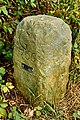
St. Vitus stone
The St. Vitus stone ( coordinate ) is located at the border point of the parishes of Südlohn , Vreden and Winterswijk . In the past, Stadtlohn was also adjacent here. A border post at this location was renewed as early as 1590. Presumably there has been a boundary marker at this point since the founding of the parish of St. Vitus Südlohn in 1231.
The Vitus stone was erected on October 29, 1753 as a replacement for an outdated border post. It is richly decorated and bears the inscription "Renovatum 1753" next to the Munster bar and the Geldrian lion coat of arms. It is older than the stones set according to the Burlo Convention. The number 79 according to the Burlo Convention and the year 1766 were added later when the other boundary stones were set. A metal plate with the number 788 is attached to the stone, which shows the counting of stones from the 19th century.
Hook stone
Together with the St. Vitus Stone, the Hakenstein was set around two kilometers south of this near the Hesselinkweg at the edge of the forest ( coordinate ) in 1753 . It was also a replacement for a rotten wooden stake. The hook stone was also included in the count of the boundary stones erected in 1766 and was given the number 86. The letters “Hertogdom Geldern” or “Fürstbistum Münster” can still be seen above the coat of arms. These inscriptions were originally also present on the St. Vitus stone, but have now been repulsed or no longer recognizable.
So-called hook stones used to mark points at which the border significantly changed direction. The origin of the name for this stone is somewhat obscure, as the border does not experience any fundamental change in direction at its location. A hook post originally stood a little further south. According to a new count, the stone bears the number 784 B.
- Selected boundary stones from the 18th century between the Dutch Achterhoek and Westmünsterland

Jurisdictiepaal at the intersection of Münster, Geldern and Overijssel

St. Vitus stone,
set again in 1753
Hook stone,
also renewed in 1753
Prince stone from 1766 with Geldrisches coat of arms near Dinxperlo / Suderwick
Letterstein am Sandheck near Oeding
.jpg)
.jpg)
.jpg)

.jpg)
Developments since the signing of the Burlo Convention
From the end of the Holy Roman Empire to the Congress of Vienna
The Principality of Münster only existed for a comparatively short time after the Burlo Convention came into force. In the course of secularization , a large part of the Münster bishopric fell to Prussia . The driving force behind the disempowerment of the church and its possessions was France, which in 1795 occupied the left bank of the Rhine and the Netherlands. The former offices of Ahaus and Bocholt ended in 1803 together with the rule of Anholt in the Principality of Salm with the capital of Bocholt ( Reichsdeputationshauptschluss ), in 1806 the former imperial rule of Gemen came into force with the entry into force of the Rhine Confederation Act . The principality was ruled as a condominium for the Salm-Salm and Salm-Kyrburg houses , which were compensated for their loss of territory on the left bank of the Rhine.
In the Netherlands occupied by French troops, the Batavian Republic replaced the Republic of the Seven United Provinces as early as 1795 . From 1798 the Batavian Republic consisted of eight departments based on the French model. In turn it was converted into the Kingdom of Holland in 1806 , headed by Louis Bonaparte , brother of the French Emperor Napoleon . After Napoleon became dissatisfied with some developments in the Kingdom of Holland, in particular with the implementation of the continental blockade against the British Empire , he annexed the satellite state in 1810 , which thus became part of the French Empire . The trade war against Great Britain led Napoleon to incorporate all of northern Germany north of a line from Wesel to Lauenburg at the mouth of the Elbe into his empire by decree of December 26, 1810 . The Principality of Salm lost its independence on February 28, 1811 and became part of the French Empire. Its territories fell to the Département de l´Yssel-Supérieur (Oberijssel). The limit negotiated in the Burlo Convention had thus temporarily sunk to insignificance. But the establishment of the new Département de la Lippe with the capital Münster on April 27, 1811, with which the "German" areas were separated from the Département Yssel-Supérieur, restored the old border. However, it had now been downgraded to the dividing line between two local authorities of the same state.
After Napoleon's defeat in the Russian campaign and the Battle of Leipzig in 1813, the Netherlands regained its independence. With the withdrawal of the French, the Münsterland was occupied by Prussian troops. In accordance with the resolutions of the Congress of Vienna to reorganize Europe in 1815 , the more southern territories of today's Belgium and Luxembourg were also united with the northern provinces in the Kingdom of the United Netherlands . France had to surrender all annexed areas, the Westmünsterland was added to the Kingdom of Prussia as part of the province of Westphalia ; Münster was appointed provincial capital. The border established by the Burlo Convention in 1765 thus again separated two independent states; its course was confirmed in the Prussian-Dutch treatise by Kleve of October 7, 1816; Land owned by German farmers on the Dutch side has since been referred to as tract land . In the same year the old districts of Ahaus and Borken were set up, which existed until December 31, 1974.
Reorganization of the diocese borders
In 1821, with the papal bull De salute animarum, the diocese borders were adapted to the new political realities. The diocese of Münster transferred the parishes of Aalten, Borculo, Bredevoort, Eibergen, Groenlo, Lichtenvoorde and Winterswijk, which were in the Achterhoek and which were restored in the 18th century, to the diocese of Utrecht . Around 7740 Catholics were among these seven districts (as of 1817). Since then, the western border of the diocese of Münster has been the state border in the Borken and Ahaus districts.
Prussian border markings from the 19th century
.jpg)
The Klever Tractate provided for the common border between Prussia and the Netherlands between the border with France in the south and the Kingdom of Hanover in the north to be provided with new border markings. In 1817 oak wooden stakes were set between the Luxembourg town of Schengen and Gronau , which were painted black and white on the Prussian side and orange and white on the Dutch side. In the area of the border negotiated by the Burlo Convention, this resulted in no changes; the new piles were placed between the existing boundary stones from 1766. In some cases, inadequate explanations and omissions by the responsible mayors ensured that the staling could only be completed around two years later. The last two of these piles survived in the Burlo-Vardingholter Venn until the second half of the 20th century. The last of them was ripped from the ground in June 1967 and thrown into the bog.
As early as 1820, proposals were made to replace the wooden border markings with more permanent stone signs. However, it took around 80 years until the border was completely petrified with the new obelisks made of blue basalt, basalt lava or sandstone, which are now commonly referred to as Reichs- or Bismarcksteine .
Minor border changes in the 19th century
The cross-border grazing right laid down in the Burlo Convention according to the ius compascuum ductu naturae hindered the division of brands and thus the agricultural development along the border. From 1821 onwards, bilateral negotiations were started, which ended in an agreement on April 11, 1827 in Coesfeld. This provided for the complete abolition of the cross-border grazing right. Since this would have meant some hardship for the farmers and shepherds affected, an adjustment was made in which the boundary line established in Burlo in 1765 was slightly changed in some areas. The boundary stones affected by the change were then moved to the new demarcation line.
In 1873/74, the Rietstapper Bridge on the border with Anholt was transferred to Prussia, which from then on was also responsible for the maintenance and upkeep of the Aa crossing. On a section of the Hellweg between Suderwick and Dinxperlo, a number of boundary stones were slightly moved. Finally, in 1879, the boundary to the Woold peasantry was slightly changed by placing a few intermediate stones and the middle of the Dambeek brook was declared the boundary.
Customs between Westmünsterland and Achterhoek

Until about 1800 people were allowed to cross the border unhindered almost everywhere. Until then, road tolls were only levied in individual cases. When Napoleon Bonaparte was preparing to take control of Europe, he imposed the continental lock on the British Isles in 1806 in order to bring the United Kingdom to its knees by means of economic warfare. During this time, French customs officers , so-called Douaniers , and military personnel were relocated to the Principality of Salm to guard the border .
The actual customs system was installed after the Congress of Vienna with the Prussian Customs Act of May 26, 1818. Crossing the border was only permitted at official border crossings, import duties were levied on the import of goods across the border, which primarily served as protective duties for one's own economy, and special border documents were required. Customs border districts were created in the border area , for which special regulations applied. The customs station in Oeding on the road from Münster via Coesfeld to Winterswijk developed into the most important border crossing in the border section covered by the Burlo Convention . The secondary customs offices of Maxhafen, Gronau, Alstätte, Vreden, Bocholt and Anholt were subordinate to the main customs office in Rheine. In 1828 responsibility changed to the main tax office in Coesfeld, which was responsible for customs and consumption tax supervision. The secondary customs offices of the 1st class in Anholt, Bocholt, Oeding, Vreden, Beßlinghook and Gronau as well as the customs offices of the 2nd class in Ellewick (Zwillbrock), Glanerbrücke, Argena (Anholt), Kreuzkapelle (Barlo), Oldenkott and Suderwick were assigned. In 1854 the main customs office moved to Vreden, which is closer to the border. In 1908 a new main customs office consisting of parts of the Vredener and Münster customs offices was brought into being in Gronau in order to take account of the increased importance of the rapidly growing industrial city and the high frequency of the nearby Glanerbrücke border crossing. The Vreden office was relocated to Borken in 1935 , which was located on the important cross-border railway line from the Ruhr area to Zutphen . In 1966, five years after the cessation of passenger traffic on this route, the offices in Borken and Gronau were merged to form the main customs office in Gronau, which was later disbanded in the course of the creation of the European internal market and the elimination of border controls in the Schengen area .
Between Gronau and Anholt there was with Bocholt- shirts , Südlohn-Oeding and Gronau-Glanerbrücke three main border crossings, of which last Oeding and Gronau were occupied around the clock. In shirts and at the smaller stations like Oldenkott, Zwillbrock, Vreden-Gaxel and Barlo, the barriers were lowered at night.
With the introduction of customs, smuggling flourished as elsewhere between Westmünsterland and Achterhoek . This concerned consumer goods such as coffee, tobacco and alcoholic beverages, but cattle and horses were also brought across the border on a large scale in some cases. The region experienced a heyday of smuggling as a result of the currency collapse following the First World War . The topic is thematically taken up by the smuggling route ( Dutch : Smokkelroute ), which accompanies the border near Bocholt, Isselburg and Anholt.
Dinxperlo and Suderwick - a special story

Between the neighboring communities of Dinxperlo and Suderwick , the state border runs along the Hellweg, which is Dutch in its entirety. The two villages were separated from each other twice by structural measures in the 20th century. During the First World War (1914–1918) the Dutch erected a high fence to underline their neutrality and prevent smuggling. However, the fence was not placed directly on the border, but along the curb on the Geldrischen side so that the Suderwickers could continue to use the road as agreed. The second time, this time from the German side, the border was blocked during World War II . From December 26, 1939, a two and a half meter high barbed wire fence was erected to prevent those persecuted by the Nazi regime from escaping. The barrier was rolled down during Operation Plunder when the Allies marched in at the end of March 1945, but the Netherlands soon replaced it with a roll-wire barriers. After the end of the war, the British occupying forces set up a border security zone on the German side of the border. In fact, it was a strip of no man's land one to two kilometers wide that was not allowed to be entered in order to prevent border crossings and smuggling. As a result, Suderwick was forcibly evacuated in early May 1945. In November 1945, the exclusion zone in Suderwick was reduced to a width of around 500 m, and most of the houses, often looted and stripped of their roofing tiles, could be moved back into.
After the end of the war, considerations arose in the Netherlands to seek compensation for the injustice suffered by the annexation of German territories . Even if the plans were not implemented on the whole, 65.8 hectares of Suderwicks were annexed in 1949, and 348 residents of the border community involuntarily moved to the other side of the border. "Suderwick-West" was not returned to the Federal Republic until August 1, 1963, after the German-Dutch State Treaty had solved the problems of the two neighboring states that were still open after the war. With this, the border between Suderwick and Dinxperlo - apart from a small exchange of land - was set back to the line of 1765 that was in force when the Burlo Convention was concluded.
Themed hiking trail "Kommiesenpatt - Kommiezenpad"
In a German-Dutch joint project, the municipalities of Südlohn and Winterswijk have created a themed hiking trail known as Kommiesenpatt ( Dutch : Kommiezenpad ) ( Low German "Kommiese" = customs officer, "Patt" = path, path). The 17.9 kilometer long main hiking route leads on both sides of the border on old control routes and smugglers' paths past the historical border markings from St. Vitus Stone to Mariengarden Monastery , where the Burlo Convention was concluded. Four circular hiking trails complement the main route and lead u. a. also to Burlo-Vardingholter Venn , which is part of a cross-border high moor area. Parts of the Kommiesenpatt can also be covered by bike, as a rider or by carriage. 50% of the project was financed by the municipalities of Südlohn and Winterswijk, the other half came from EU and EUREGIO funds. A bilingual (German / Dutch) brochure has been published on the Kommiesenpatt, which is available from the Grenzlandgemeinden.
Anniversary activities 2015
On October 24, 2015, the 250th anniversary of the signing of the Burlo Convention was commemorated in a ceremony in the forum of the Burloer Gymnasium Mariengarden . The border communities of Aalten, Berkelland , Oost Gelre , Winterswijk, Bocholt, Borken, Südlohn, Vreden and the local homeland associations had invited to this event under the motto Connecting borders . This was followed by the opening of the traveling exhibition 250 Years of the Border , which will be presented during the anniversary year at various locations on both sides of the border. Further activities follow. In 2016, a new border crossing for pedestrians and cyclists is to be opened on the edge of the Burlo-Vardingholter Venn in the extension of the Vennweg. The Winterswijker Marathon was organized across borders on September 18, 2016.
literature
- Hermann Terhalle: On the history of the Westphalian-Dutch border . Ed .: Heimatverein Vreden (= contributions of the Heimatverein Vreden to regional and folklore . Volume 75 ). Self-published, Vreden 2008, ISBN 978-3-926627-53-7 .
- District Home Letter Borken No. 238. (PDF) District Home Care Borken, 7 September 2015, p. 8ff. , accessed on October 26, 2015 (file size 7.31 MB).
Web links
- Hermann Terhalle: From the territorial border to the state border - the emergence of the Westphalian-Dutch border
- Hermann Terhalle: The western Münsterland - the formation of a border region , archive maintenance in Westphalia-Lippe 77/2012
- Kommiesenpatt. (PDF; 2.9 MB) Hiking on customs officers and smugglers' trails across the green border. Municipality of Südlohn and Gemeente Winterswijk , 2007, accessed on August 13, 2015 (German, Dutch, bilingual, German-Dutch brochure).
- “Kommiesenpatt” - hiking on customs officers and smuggler trails across the green border. (PDF) 2007, accessed on June 13, 2015 (German, Dutch, bilingual, German-Dutch brochure).
- Henk Krul: imperial stones and princely stones. (PDF) A border inspection between Münsterland and Gelderland. In: Our Bocholt. 1960, accessed May 28, 2015 .
- Dinxperlo borderland museum
See also
Individual evidence
- ↑ a b c d Hermann Terhalle: From the Territorial Border to the State Border - The Origin of the Westphalian-Dutch Border ( Memento of the original from January 25, 2016 in the Internet Archive ) Info: The archive link was automatically inserted and not yet checked. Please check the original and archive link according to the instructions and then remove this notice.
- ^ Elisabeth Piirainen, Wilhelm Elling: Dictionary of the West Munsterland dialect. (PDF) In: Contributions of the Heimatverein Vreden on regional and folklore vol. 40. Heimatverein Vreden, p. 1 , accessed on June 26, 2015 (Vreden 1992, ISBN 3-926627-09-3 ).
- ↑ Bishop Ludwig II , Landgrave of Hesse, acquired the lordship of Lohn including the castle Bredevoort from Johann and Otto von Ahaus in 1316 , after the line of the Lohn family had expired in the same year with the death of the last Count Hermann II von Lohn , see Detlef Fischer: Chronicle of the Münsterland . 1st edition. Aschendorff , Münster 2003, ISBN 3-402-05343-8 , pp. 68 . / Purchase of the Herrschaft Lohn by the Bishop of Münster , Internet portal for Westphalian history at the LWL .
- ↑ Detlef Fischer: Chronicle of the Münsterland . 1st edition. Aschendorff , Münster 2003, ISBN 3-402-05343-8 , pp. 89 f .
- ^ A b c Hermann Terhalle: The western Münsterland - the formation of a border region , archive maintenance in Westphalia-Lippe 77/2012.
- ↑ a b c Hermann Lübbering: Burlo Monastery. History of the Mariengarden monastery in Groß-Burlo. Published by the Heimatverein Vreden, self-published, Vreden 1981 ( Contributions by the Heimatverein Vreden on regional and folklore booklet 20), p. 116 ff.
- ↑ a b c d Kommiesenpatt. (PDF; 2.9 MB) Hiking on customs officers and smugglers' trails across the green border. Municipality of Südlohn and Gemeente Winterswijk , 2007, accessed on August 13, 2015 (German, Dutch, bilingual, German-Dutch brochure).
- ^ Nikolaus Philippi: Landmarks in Germany . Verlag Rockstuhl , Bad Langensalza 2009, ISBN 978-3-86777-125-2 ( limited preview in Google book search).
- ↑ See Hermann Terhalle: On the history of the Westphalian-Dutch border . Ed .: Heimatverein Vreden (= contributions of the Heimatverein Vreden to regional and folklore . Volume 75 ). Self-published, Vreden 2008, ISBN 978-3-926627-53-7 . , Pp. 133, 136.
- ^ A b Hermann Terhalle: The identification of the Munsterisch-Geldrischen border by the Burlo Convention of 1765 (= Grenzlandbegegegen = Grenslandontmoetingen . No. 5 ). Borken / Winterswijk 1983, p. 48-58 .
- ↑ De Gelders-Münsterse Grens from 1765/66. (url) Retrieved June 22, 2015 (Dutch).
- ^ Hermann Terhalle: On the history of the Westphalian-Dutch border . Ed .: Heimatverein Vreden (= contributions of the Heimatverein Vreden to regional and folklore . Volume 75 ). Self-published, Vreden 2008, ISBN 978-3-926627-53-7 , pp. 146 .
- ↑ Kees van Rijn: Grenspalen. (PDF) (No longer available online.) Formerly in the original ; Retrieved June 19, 2015 (Dutch). ( Page no longer available , search in web archives ) Info: The link was automatically marked as defective. Please check the link according to the instructions and then remove this notice.
- ↑ Henk Krul: Imperial stones and prince stones. (PDF) A border inspection between Münsterland and Gelderland. In: Our Bocholt. 1960, accessed May 28, 2015 .
- ↑ See e.g. B. Smuggling route on Buchen-holland.de/ .
- ↑ See pictures and explanations on the pages of the Suderwick home association
- ^ Dictionary of West Munsterland dialect
- ↑ "Kommiesenpatt" - hiking on customs officers and smugglers' paths across the green border. (PDF) 2007, accessed on June 13, 2015 (German, Dutch, bilingual, German-Dutch brochure).
- ↑ Borio-TV of October 26, 2015: Ceremony for the opening of the anniversary year
- ↑ 250 years peace treaty - Burlo Monastery. (PDF) City of Borken, 2015, accessed on September 28, 2015 .
- ↑ Kreisheimatbrief Borken No. 238. (PDF) Kreisheimatpflege Borken, 7 September 2015, p. 8ff. , accessed on October 26, 2015 (file size 7.31 MB).
Remarks
- ↑ The maps are now in the NRW State Archives, Westphalia Department, Münster, and are available online as digital copies.
- ↑ On the German side borders here which belongs to Vreden peasantry to Wennewick. On the Geldr side, it is the Rekken farming community belonging to the Berkelland community and Haaksbergen in Overijssel .
- ↑ The Riedstapper or Restapper Bridge is a crossing over the Bocholter Aa on the border from Dinxperlo (Netherlands) to Suderwick ( Bocholt ) and Isselburg .
- ↑ 39.5 cm × 39.5 cm × 157 cm or 31.4 cm × 31.4 cm × 125.6 cm
- ↑ The Niekerk or New Church was no longer in use at that time. The name has been preserved to this day. The Niekerkerweg runs on the Dutch side of the border .
- ↑ The old districts of Ahaus and Borken were merged to form the new district of Borken on January 1, 1975 as part of the regional reform in North Rhine-Westphalia with the Münster / Hamm Act .