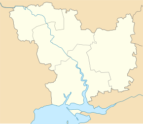
Krasnopillja (Beresanka)
| Krasnopillja | ||
| Краснопілля | ||

|
|
|
| Basic data | ||
|---|---|---|
| Oblast : | Mykolaiv Oblast | |
| Rajon : | Berezanka district | |
| Height : | 36 m | |
| Area : | 5.678 km² | |
| Residents : | 1,083 (2004) | |
| Population density : | 191 inhabitants per km² | |
| Postcodes : | 57434 | |
| Area code : | +380 5153 | |
| Geographic location : | 46 ° 52 ' N , 31 ° 15' E | |
| KOATUU : | 4820982401 | |
| Administrative structure : | 1 village, 1 settlement | |
| Address: | вул. Шкільна 1 57434 с. Краснопілля |
|
| Website : | City council website | |
| Statistical information | ||
|
|
||
Krasnopillja ( Ukrainian Краснопілля ; Russian Краснополье Krasnopolje ; former German name "Blumenfeld" ) is a village in the southwest of the Ukrainian Oblast Mykolaiv with about 1000 inhabitants (2004).
Krasnopillja is the administrative center of the 8.572 km² district council of the same name in the west of Berezanka district , to which the settlement Krutoyarka ( Крутоярка ⊙ ) with about 120 inhabitants belongs.
The village lies at an altitude of 36 m between the Tylihul Liman in the west and the Beresanka district center 15 km in the east. Mykolaiv Oblast Center is 70 km east of the village.
In 1886, 143 Black Sea Germans lived in the then (officially until 1944) called Blumenfeld . Between 1900 and 1902 they built the St George Church, which cost 30,000 rubles at the time and is still in ruins today.
Sons and daughters of the village
- Gerhard Sawatzky (1901–1944), Russian-German writer
Web links
Individual evidence
- ↑ local website of the village on the official site of the Verkhovna Rada ; accessed on April 13, 2017
- ↑ Memorial plaque for the founders of the village of Krasnopole (Blumenfeld) ; at Nykolaewskyj Bazaar, accessed April 13, 2017 (Russian)


