Krassivaya Mecha
|
Krassiwaja Metscha Краси́вая Меча́ |
||
|
Krasivaya Mecha near Yefremov |
||
| Data | ||
| Water code | RU : 05010100112107000000535 | |
| location | Tula Oblast , Lipetsk ( Russia ) | |
| River system | Don | |
| Drain over | Don → Black Sea | |
| source | in the east of the Central Russian Plate 53 ° 35 ′ 28 ″ N , 37 ° 48 ′ 36 ″ E |
|
| muzzle | south of Lebedjan in the Don Coordinates: 52 ° 55 ′ 19 " N , 39 ° 2 ′ 53" E 52 ° 55 ′ 19 " N , 39 ° 2 ′ 53" E
|
|
| length | 244 km | |
| Catchment area | 6000 km² | |
| Outflow location: 22 km above the mouth |
MQ |
30.2 m³ / s |
| Medium-sized cities | Yefremov | |
|
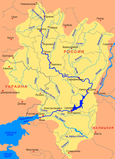
Location of the Krassiwaja Mecha (Краси́вая Меча́) in the Don catchment area |
||
The Krassiwaja Metscha ( Russian Краси́вая Меча́ ) is a right tributary of the Don in the Russian oblasts of Tula and Lipetsk .
The Krassiwaya Metscha rises in the east of the Central Russian Plate in the Tula Oblast. It flows in a mostly south-easterly direction into the Lipetsk Oblast. She passes the city of Yefremov . After 244 km south of Lebedjan, the Krassiwaya Metscha finally flows into the upper reaches of the Don on the right side. The river drains an area of about 6000 km². It is mainly fed by the snowmelt . Floods regularly occur in March and April . 22 km above the mouth, the mean discharge (MQ) is 30.2 m³ / s. The largest runoffs reached values of 1360 m³ / s. The river is ice-covered every year between late November / early December and late March.
Individual evidence
- ↑ a b c d e f Article Krassiwaja Metscha in the Great Soviet Encyclopedia (BSE) , 3rd edition 1969–1978 (Russian)
- ↑ a b Krasiwaja Metscha in the State Water Directory of the Russian Federation (Russian)

