Zalaszentgrót district
| circle Zalaszentgróti járás
Zalaszentgrót |
|
|---|---|
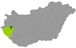
 Location of the district in Hungary |
|
| Basic data | |
| Country | Hungary |
| County | Zala |
| Seat | Zalaszentgrót |
| surface | 282.5 km² |
| Residents | 15,055 (January 1, 2016) |
| density | 53 inhabitants per km² |
The district of Zalaszentgrót ( Hungarian Zalaszentgróti járás ) is a district in the northeast of the southwestern Hungarian Zala County . The district borders on the Zalaegerszeg district to the west and the Keszthely district in the southeast . Sümeg County ( Veszprém County ) forms the border in the northeast, and Vasvár and Sárvár County ( Vas County ) in the north .
history
During the Hungarian administrative reform in early 2013, the district emerged from the small area of the same name (Hungarian: Zalaszentgróti kistérség ), which also gave five municipalities to the districts of Zalaegerszeg and Keszthely . This corresponded to 13.6% of the area or 9.3% of the population of the former small area.
Community overview
The district of Zalaszentgrót has an average municipality size of 753 inhabitants on an area of 14.13 square kilometers. The population density of the smallest and least populous district is below the county average. The district seat is located in the only town, Zalaszentgrót , in the center of the district.
| 20 municipalities | status | Origin small area |
population | Area (km²) | Population density (inh / km²) |
||
|---|---|---|---|---|---|---|---|
| October 01, 2011 | 01/01/2013 | 01/01/2016 | |||||
| Batyk | local community | Zalaszentgrót | 384 | 391 | 370 | 8.08 | 45.8 |
| Döbröce | local community | Zalaszentgrót | 66 | 63 | 73 | 2.70 | 27.0 |
| Dötk | local community | Zalaszentgrót | 25th | 27 | 36 | 1.72 | 20.9 |
| Kallósd | local community | Zalaszentgrót | 83 | 91 | 92 | 5.41 | 17.0 |
| Kehidakustány | local community | Zalaszentgrót | 1,189 | 1,218 | 1,180 | 19.75 | 59.7 |
| Kisgörbő | local community | Zalaszentgrót | 167 | 165 | 157 | 6.59 | 23.8 |
| Kisvásárhely | local community | Zalaszentgrót | 49 | 44 | 42 | 4.35 | 9.7 |
| Mihályfa | local community | Zalaszentgrót | 348 | 368 | 350 | 12.07 | 29.0 |
| Nagygörbő | local community | Zalaszentgrót | 180 | 166 | 153 | 7.45 | 20.5 |
| Óhíd | local community | Zalaszentgrót | 601 | 609 | 588 | 12.48 | 47.1 |
| Pakod | local community | Zalaszentgrót | 921 | 891 | 855 | 12.55 | 68.1 |
| Sénye | local community | Zalaszentgrót | 28 | 35 | 31 | 3.04 | 10.2 |
| Sümegcsehi | local community | Zalaszentgrót | 621 | 629 | 619 | 17.44 | 35.5 |
| Szalapa | local community | Zalaszentgrót | 200 | 208 | 189 | 4.52 | 41.8 |
| Tekenye | local community | Zalaszentgrót | 417 | 407 | 400 | 6.96 | 57.5 |
| Türje | local community | Zalaszentgrót | 1,637 | 1,638 | 1,582 | 38.23 | 41.4 |
| Zalabér | local community | Zalaszentgrót | 727 | 705 | 707 | 12.78 | 55.3 |
| Zalaszentgrót | city | Zalaszentgrót | 6,626 | 6,634 | 6,448 | 74.65 | 86.4 |
| Zalaszentlászló | local community | Zalaszentgrót | 870 | 857 | 824 | 19.66 | 41.9 |
| Zalavég | local community | Zalaszentgrót | 370 | 372 | 359 | 12.11 | 29.6 |
| Zalaszentgrót district | 15,509 | 15,518 | 15,055 | 282.54 | 53.3 | ||
swell
PDF and XLS files: 2011
Census :
2013:; 2016:
Individual evidence
- ↑ KSH: 2011. Évi Népszámlálás. In: 3. Területi adatok. KSH, accessed on December 27, 2016 (Hungarian, also via: http://www.terezvaros.hu/testuleti/nepsz2011-3/pdf/nepsz2011_03_20.pdf ).
- ↑ KSH: Regional data - Zala county. KSH, accessed on December 27, 2016 (English, 4th Data on Localities).
- ↑ KSH: Gazetteer of Hungary, 1st January, 2013. KSH, accessed April 13, 2017 (Hungarian / English).
- ↑ KSH: Gazetteer of Hungary, 1st January, 2016. KSH, accessed April 13, 2017 (Hungarian / English).