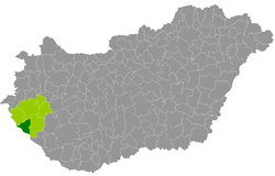
Letenye County
| circle Letenyei járás
Letenye |
|
|---|---|
 Location of the district in Hungary |
|
| Basic data | |
| Country | Hungary |
| County | Zala |
| Seat | Letenye |
| surface | 388.7 km² |
| Residents | 15,664 (January 1, 2016) |
| density | 40 inhabitants per km² |
The Letenye District ( Hungarian Letenyei járás ) is a district in the northwest of the southwestern Hungarian Zala County . It borders in the north-west on the Lenti district , in the north on the Zalaegerszeg district and in the east on the Nagykanizsa district . In the west, 6 municipalities form the state border with Croatia .
history
During the Hungarian administrative reform in early 2013, the district emerged unchanged from the small area of the same name (Hungarian Letenyei kistérség ).
Community overview
The Letenye District has an average municipality size of 580 inhabitants in an area of 14.39 square kilometers. The population density of the district with the second lowest population is the second lowest in the county. The district seat is in the only town, Letenye , in the southwest of the district.
| 27 municipalities | status | Origin small area |
population | Area (km²) | Population density (inh / km²) |
||
|---|---|---|---|---|---|---|---|
| October 01, 2011 | 01/01/2013 | 01/01/2016 | |||||
| Bánokszentgyörgy | local community | Letenye | 642 | 650 | 618 | 32.54 | 19.0 |
| Bázakerettye | local community | Letenye | 842 | 861 | 786 | 8.03 | 97.9 |
| Becsehely | local community | Letenye | 2,102 | 2,080 | 2,025 | 36.08 | 56.1 |
| Borsfa | local community | Letenye | 745 | 736 | 708 | 11.83 | 59.8 |
| Bucsuta | local community | Letenye | 219 | 227 | 209 | 16.19 | 12.9 |
| Csörnyeföld | local community | Letenye | 402 | 420 | 389 | 21.21 | 18.3 |
| Kerkaszentkirály * † | local community | Letenye | 221 | 228 | 209 | 8.11 | 25.8 |
| Kiscsehi | local community | Letenye | 168 | 170 | 173 | 11.43 | 15.1 |
| Kistolmács | local community | Letenye | 175 | 181 | 176 | 12.20 | 14.4 |
| Lasztonya | local community | Letenye | 91 | 86 | 73 | 8.77 | 8.3 |
| Letenye * | city | Letenye | 4,192 | 4,202 | 4,060 | 41.74 | 97.3 |
| Lispeszentadorján | local community | Letenye | 291 | 289 | 278 | 9.14 | 30.4 |
| Maróc | local community | Letenye | 83 | 76 | 71 | 5.16 | 13.8 |
| Molnari * | local community | Letenye | 721 | 718 | 705 | 12.86 | 54.8 |
| Murarátka * | local community | Letenye | 252 | 245 | 224 | 12.04 | 18.6 |
| Muraszemenye * † | local community | Letenye | 656 | 626 | 584 | 16.15 | 36.2 |
| Oltárc | local community | Letenye | 281 | 283 | 260 | 29.53 | 8.8 |
| Petrivente | local community | Letenye | 364 | 362 | 327 | 7.65 | 42.7 |
| Pusztamagyaród | local community | Letenye | 593 | 576 | 543 | 16.02 | 33.9 |
| Semjénháza | local community | Letenye | 599 | 601 | 579 | 4.70 | 123.2 |
| Szentliszló | local community | Letenye | 275 | 281 | 258 | 6.89 | 37.4 |
| Szentmargitfalva | local community | Letenye | 89 | 85 | 73 | 3.12 | 23.4 |
| Tótszentmárton | local community | Letenye | 836 | 840 | 819 | 10.17 | 80.5 |
| Tótszerdahely * | local community | Letenye | 1,100 | 1,096 | 1,045 | 12.29 | 85.0 |
| Valkonya | local community | Letenye | 56 | 55 | 50 | 7.55 | 6.6 |
| Várfölde | local community | Letenye | 183 | 191 | 187 | 14.87 | 12.6 |
| Zajk | local community | Letenye | 232 | 248 | 235 | 12.39 | 19.0 |
| Letenye County | 16,410 | 16,413 | 15,664 | 388.66 | 40.3 | ||
* Border municipality to Croatia
† border municipality to Slovenia
swell
PDF and XLS files: 2011
Census :
2013:; 2016:
Individual evidence
- ↑ KSH: 2011. Évi Népszámlálás. In: 3. Területi adatok. KSH, accessed on December 27, 2016 (Hungarian, also via: http://www.terezvaros.hu/testuleti/nepsz2011-3/pdf/nepsz2011_03_20.pdf ).
- ↑ KSH: Regional data - Zala county. KSH, accessed on December 27, 2016 (English, 4th Data on Localities).
- ↑ KSH: Gazetteer of Hungary, 1st January, 2013. KSH, accessed April 13, 2017 (Hungarian / English).
- ↑ KSH: Gazetteer of Hungary, 1st January, 2016. KSH, accessed April 13, 2017 (Hungarian / English).