Kuskulana River
| Kuskulana River | ||
|
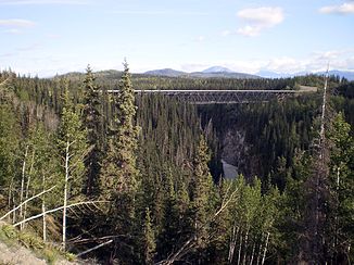
Kuskulana River Bridge on McCarthy Road |
||
| Data | ||
| Water code | US : 1405088 | |
| location | Alaska (USA) | |
| River system | Copper River | |
| Drain over | Chitina River → Copper River → Gulf of Alaska | |
| origin |
Kuskulana Glacier in the Wrangell Mountains 61 ° 37 ′ 8 ″ N , 143 ° 41 ′ 34 ″ W |
|
| muzzle |
Chitina River Coordinates: 61 ° 28 ′ 12 " N , 144 ° 10 ′ 55" W 61 ° 28 ′ 12 " N , 144 ° 10 ′ 55" W. |
|
| Mouth height |
168 m
|
|
| length | approx. 35 km | |
The Kuskulana River is an approx. 35 km long right tributary of the Chitina River in southern Alaska (USA).
It rises from the Kuskulana Glacier on Mount Blackburn in the Wrangell Mountains . The Kuskulana River flows in a south-westerly direction and finally flows into the Chitina River, which flows west . The Kuskulana River is part of the river system of the Copper River , of the Gulf of Alaska flows.
At mile 17.4 (28 km) on McCarthy Road , the Kuskulana River Bridge spans the canyon of the river. The steel girder bridge was built in 1910 as a railway bridge and is now used for road vehicles.
