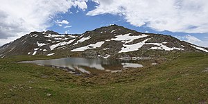
Lai da Chazfora
| Lai da Chazfora | ||
|---|---|---|

|
||
| Geographical location | Canton of Graubünden , Switzerland | |
| Drain | Rambach → Etsch → Adriatic Sea | |
| Location close to the shore | Tschierv | |
| Data | ||
| Coordinates | 821.37 thousand / 164 789 | |
|
|
||
| Altitude above sea level | 2595 m above sea level M. | |
| surface | 0.235 3 ha | |
| length | 72 m | |
| width | 56 m | |
| scope | 204 m | |
The Lai da Chazfora ( Romansh lai for, See 'and chazfora , skimmer , probably' from Sassforà reinterpreted) is a mountain lake in Val Müstair , above Tschierv in the canton of Grisons in the Swiss Alps . He is at 2595 m above sea level. M.
Location and surroundings
The lake is located in the Ötztal Alps , nestled between Piz Turettas , Piz Chazforà and Piz Dora .
Access
From Tschierv
- Starting point: Tschierv ( 1660 m )
- Via: Funtauna Grossa, Lai Zoppa
- Difficulty: T3 , as trail white-red-white marks
- Time required: 2¾ hours
From Fuldera
- Starting point: Fuldera ( 1638 m )
- Via: Sadra, Alp Sadra, Muntet
- Difficulty: T3 , as trail white-red-white marks
- Time required: 3 hours
Through the Val Mora
- From Valchava via Las Clastras, Praveder, La Stretta, Alp Sprella
- From the Ofen Pass via Davo Plattas, Döss da las Plattas ( 2296 m ), Alp Mora, Alp Sprella
- 5½ hours from Valchava
- 4 hours from the oven pass
literature
- National map of Switzerland, sheet 1239 Sta Maria, 1: 25,000, Federal Office of Topography, 2017 edition
- Sabine Joss, Fredy Joss: Alpine hiking / Engadin, summit destinations between Samnaun and Bergell . Verlag des SAC, 2010, ISBN 978-3-85902-327-7 , p. 170-173 .
Web links
Commons : Lai da Chazfora - collection of images, videos and audio files
- Lai da Chazfora on schweizersee.ch
Individual evidence
- ↑ Andrea Schorta: How the mountain got its name . Small Rhaetian name book with two and a half thousand geographical names of Graubünden. Terra Grischuna Verlag, Chur and Bottmingen / Basel 1988, ISBN 3-7298-1047-2 , p. 77 .


