Lake Chemong
| Lake Chemong | ||
|---|---|---|

|
||
| Geographical location | Ontario ( Canada ) | |
| Drain | Harrington Narrows to Buckhorn Lake | |
| Location close to the shore | Peterborough | |
| Data | ||
| Coordinates | 44 ° 24 ′ N , 78 ° 23 ′ W | |
|
|
||
| Altitude above sea level | 245 m | |
| length | 14 km | |
| width | 1 km | |

|
||
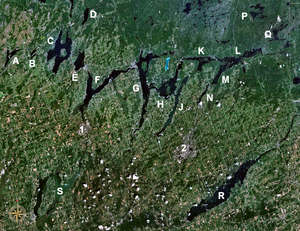
| The Kawartha Lakes, Lake Chemong pictured as "J" | ||
The lake chemong or Chemong Lake is a lake in the Canadian province of Ontario .
It is located 8 km northwest of Peterborough near the town of Bridgenorth . Communities on and near the lake are Bridgenorth and Selwyn to the east and Ennismore Township to the west. The James A. Giffort Dam crosses the lake and connects Bridgenorth and Ennismore by road.
The lake is 14 km long and 1 km wide. Lake Chemong, together with Buckhorn Lake and Pigeon Lake, forms a three-part system that belongs to the Kawartha Lakes . Lake Chemong is connected to neighboring Buckhorn Lake by the 200 m wide Harrington Narrows .
The Trent-Severn Waterway , a canal that connects George's Bay with Lake Ontario , runs through Buckhorn Lake. Lake Chemong is ideal as a detour on a trip on this waterway. There are some small islands on the lake, including the Big Island , which means "Big Island".
There are many cottages and campsites on the shores of the lake . Many fishing tournaments are held on the lake; the most common fish are black bass , largemouth bass and muscle lung .
Although the lake is generally called Chemong , the official spelling is Chemung at a request from an Indian community. "Chemong" means "mud", which can be traced back to the former wetlands in the vicinity of the lake. These were flooded during the damming of the waters of the Trent-Severn waterway.
