Balsam Lake (Ontario)
| Balsam Lake | |||||||||
|---|---|---|---|---|---|---|---|---|---|
|
|||||||||
|
|
|||||||||
| Coordinates | 44 ° 35 ′ 0 ″ N , 78 ° 50 ′ 0 ″ W | ||||||||
| Data on the structure | |||||||||
| Construction time: | 1873 | ||||||||
| Data on the reservoir | |||||||||
| Altitude (at congestion destination ) | 256.3 m | ||||||||
| Reservoir length | 16 km | ||||||||
| Reservoir width | 3 km | ||||||||
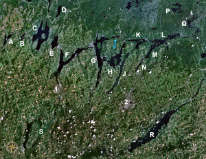
| Kawartha Lakes with Balsam Lake (as "C") | |||||||||
The Balsam Lake ( English for " Balsam -See") is a lake in the Canadian province of Ontario . It is located in the southern part of central Ontario. Balsam Lake is part of the Kawartha Lakes , a group of lakes that formed at the end of the last Ice Age and borders the Canadian Shield to the north .
Balsam Lake is 16 km long and an average of 3 km wide. In the middle of the lake is the Grand Island . The lake is divided into 4 large bays: North Bay , West Bay , South Bay and a bay in the northeast, at the end of which is the place Coboconk . The main tributary, the Gull River , flows into the lake here.
The Indian Point Provincial Park is located on the peninsula between this bay and North Bay , but it does not offer any infrastructure. Balsam Lake Provincial Park is on the northwestern shore of the lake . This offers camping and leisure opportunities.
The lake is the highest point of the Trent-Severn Waterway , a canal that connects George's Bay in Lake Huron with Lake Ontario . The lake is located at an altitude of 256 m . Thus, the lake is drained to the Georgsbucht (Huron Sea) as well as via the Trent River directly to Lake Ontario.
To the east of Balsam Lake at Rosedale is lock 35 of the Trent-Severn waterway. This was completed in 1873 and has since increased the water level of the lake by 5 m. Below the lock, the Rosedale River flows to Cameron Lake . The canal of the Trent-Severn waterway runs south of it.
To the west of Balsam Lake, the Trent-Severn Waterway Canal connects it with Mitchell Lake .
Web links
Individual evidence
- ↑ Ontario Parks - Indian Point Provincial Park ( Memento of the original from February 23, 2010 in the Internet Archive ) Info: The archive link was automatically inserted and has not yet been checked. Please check the original and archive link according to the instructions and then remove this notice.
- ↑ Ontario Parks - Balsam Lake Provincial Park ( Memento of the original from July 16, 2009 in the Internet Archive ) Info: The archive link was inserted automatically and has not yet been checked. Please check the original and archive link according to the instructions and then remove this notice.

