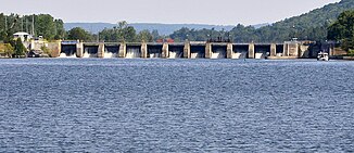
Trent River (Lake Ontario)
| Trent River | ||
| Data | ||
| location | Ontario (Canada) | |
| River system | Saint Lawrence River | |
| Drain over | Saint Lawrence River → Atlantic Ocean | |
| source |
Rice Lake 44 ° 17 ′ 49 ″ N , 77 ° 58 ′ 20 ″ W. |
|
| Source height | 187 m | |
| muzzle | near Trenton in the Bay of Quinte ( Lake Ontario ) Coordinates: 44 ° 5 ′ 54 ″ N , 77 ° 34 ′ 15 ″ W, 44 ° 5 ′ 54 ″ N , 77 ° 34 ′ 15 ″ W. |
|
| Mouth height | 75 m | |
| Height difference | 112 m | |
| Bottom slope | 1.2 ‰ | |
| length | 90 km (402 km total length to the source of the Irondale River ) | |
| Catchment area | 12,400 km² | |
| Discharge at the Trenton A Eo gauge : 12,400 km² |
MQ 1999/2002 Mq 1999/2002 |
120 m³ / s 9.7 l / (s km²) |
| Left tributaries | Crowe River | |
| Medium-sized cities | Trenton | |
| Communities | Hastings | |
|
Trent River south of Batawa Dam and Locks |
||
The Trent River is a river in the southeast of the Canadian province of Ontario . It flows from Rice Lake to the Bay of Quinte , a bay in the north of Lake Ontario . The Trent River drains much of south-central Ontario, including the Kawartha Lakes and their tributaries. The river is 90 km long.
The river is part of the Trent-Severn Waterway , which runs from Georgian Bay to the Bay of Quinte.
The river is home to a wide variety of bird, amphibian, and fish species. The fish species include black bass , largemouth bass , pike , glass eye bass , freshwater drummers and smaller fish species such as sun bass and rock bass .
Crowe River is a major left tributary of the Trent River. The Otonabee River , which flows into Rice Lake and flows through the city of Peterborough , represents a headwaters of the Trent River.
Hydropower plants
There are several hydropower plants along the Trent River. In the downstream direction these are:
| Surname | completion position |
Power [MW] |
Number of turbines |
operator |
|---|---|---|---|---|
| Healey Falls | 1910-1914 | 18th | 4th | OPG |
| Seymour | 1909 | 6th | 5 | OPG |
| Ranney Falls | 1922-1926 | 10 | 3 | OPG |
| Hagues Reach | 1925 | 4th | 3 | OPG |
| Meyersburg | 1924 | 5 | 2 | OPG |
| Sills Island | 1900 | 2 | 2 | OPG |
| Frankford | 1913 | 3 | 2 | OPG |
| Glen Miller | 2005 | 8th | 2 | Glen Miller Power LP |
| Sidney | 1911 | 4th | 3 | OPG |
See also
There is a Hamlet called the Trent River , which lies between Hastings and Campbellford on the Trent River.
Web links
- Trent watershed maps
- Lower Trent Conservation
- Trent River , Natural Resources Canada, Geographical Names of Canada
Individual evidence
- ↑ a b The Atlas of Canada - Rivers ( Memento from January 22, 2013 in the Internet Archive ) (English)
- ↑ Water Survey of Canada: Station 02HK010 ( Memento of the original from December 24, 2010) Info: The archive link was automatically inserted and not yet checked. Please check the original and archive link according to the instructions and then remove this notice.
- ↑ Ontario Power Authority ( Memento of the original from December 14, 2011 in the Internet Archive ) Info: The archive link was inserted automatically and has not yet been checked. Please check the original and archive link according to the instructions and then remove this notice.
- ^ Ontario Power Generation

