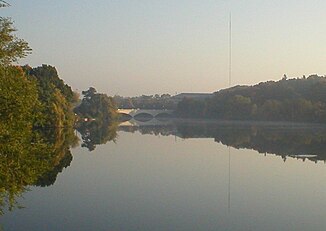
Otonabee River
|
Otonabee River Tullibee River |
||
|
Otonabee River in Peterborough, Ontario |
||
| Data | ||
| location | Ontario (Canada) | |
| River system | Saint Lawrence River | |
| Drain over | Trent River → Saint Lawrence River → Atlantic Ocean | |
| source |
Katchewanooka Lake 44 ° 25 ′ 21 ″ N , 78 ° 16 ′ 30 ″ W. |
|
| Source height | 232 m | |
| origin |
Rice Lake Coordinates: 44 ° 9 '12 " N , 78 ° 13' 51" W 44 ° 9 '12 " N , 78 ° 13' 51" W. |
|
| Mouth height | 187 m | |
| Height difference | 45 m | |
| Bottom slope | 0.82 ‰ | |
| length | 55 km | |
| Flowing lakes | Little Lake | |
| Medium-sized cities | Peterborough | |
| Small towns | Lakefield | |
|
View over the Otonabee river in Peterborough, Ontario. In the background the campus of Trent University, on the right the Faryon Bridge |
||
|
View of the Faryon Bridge |
||
Otonabee River is a river in the Canadian province of Ontario .
It forms the drain of Katchewanooka Lake near Lakefield . It flows south. It flows through the east of Peterborough (at a distance of 150 m from the city center) and the Little Lake there . It flows another 30 km to the south. It finally flows into the northwestern part of Rice Lake , which is drained from the Trent River to Lake Ontario . The total length of the Otonabee River is 55 km.
In the Ojibwe language , the river is called Odoonabii-ziibi ("Tullibee River"). "Tullibee" is another name for the American whitefish ( Coregonus artedi ).
The banks of the Otonabee River have often been hit by floods as a result of heavy precipitation events. For example, on July 15, 2004, 240 mm fell in some places within 24 hours. The Trent University operates its own hydropower plant on the river.
Cow Island is an island in Rice Lake west of the mouth of the Otonabee River.
use
The river is part of the Trent-Severn Waterway , which connects Lake Ontario with Lake Huron . There are a number of locks along the river. These allow the boat trip from Rice Lake up the Otonabee River to Katchewanooka Lake and on to the Kawartha Lakes .
There are several hydropower plants on the Otonabee River:
The Lakefield power plant in Lakefield supplies electricity with a 2 MW turbine. Some of the former power plant sites at the barrages of the river system have been abandoned.
The Auburn power plant in Peterborough has 3 units with an output of 2 MW.
The London Street power plant in Peterborough provides with three Francis turbines and a drop height of 8.5 m, a power of 4.1 MW.
Web links
Individual evidence
- ↑ Rice Lake to Peterborough Trent Severn Waterway - On Line Cruising Guide ( Memento of the original from April 19, 2012 in the Internet Archive ) Info: The archive link was automatically inserted and not yet checked. Please check the original and archive link according to the instructions and then remove this notice.
- ↑ a b Ontario Power Generation - Lakefield Station
- ^ Ontario Power Generation - Auburn Station
- ↑ Ontario Power Authority - London Street Generating Station ( Memento of the original from April 1, 2012 in the Internet Archive ) Info: The archive link was inserted automatically and has not yet been checked. Please check the original and archive link according to the instructions and then remove this notice.


