Crowe River
| Crowe River | ||
|
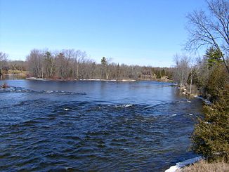
Crowe River north of Crowe Brid |
||
| Data | ||
| location | Ontario (Canada) | |
| River system | Saint Lawrence River | |
| Drain over | Trent River → Saint Lawrence River → Atlantic Ocean | |
| origin |
Paudash Lake 44 ° 58 ′ 50 ″ N , 77 ° 58 ′ 25 ″ W. |
|
| Source height | 341 m | |
| muzzle |
Trent River Coordinates: 44 ° 22 ′ 23 " N , 77 ° 45 ′ 49" W 44 ° 22 ′ 23 " N , 77 ° 45 ′ 49" W. |
|
| Mouth height | 159 m | |
| Height difference | 182 m | |
| Bottom slope | approx. 1.8 ‰ | |
| length | approx. 100 km | |
| Catchment area | approx. 2000 km² | |
| Left tributaries | Beaver Creek , Green River , Copeway Creek | |
| Right tributaries | North River | |
| Flowing lakes | Mud Turtle Lake , Tangamong Lake | |
| Reservoirs flowed through | Cordova Lake , Belmont Lake , Crowe Lake | |
Crowe River is a river in the south of the Canadian province of Ontario .
It flows through the counties of Haliburton , Hastings , Northumberland and Peterborough in southern Ontario.
It is a left tributary of the Trent River and belongs to the catchment area of Lake Ontario .
River course
The river has its origin in Paudash Lake , which it leaves at Paudash Lake Dam in a southeast direction. He crosses Highway 28 . He later turns to the southwest. It flows through a 230 m long, 30 m high and 5-10 m wide gorge in The Gut Conservation Area . Then the Green River flows into the Crowe River from the left. The river flows through Tangamong Lake , takes the left tributary Copeway Creek , flows through Mud Turtle Lake and reaches Cordova Lake , which is dammed by Cordova Lake Dam . Now he reaches Belmont Lake , into which the North River also flows. It leaves the lake at Crowe River Bay in the east via Belmont Dam and reaches nearby Crowe Lake . The Beaver Creek also flows into this . The Crowe River passes Marmora , Highway 7 and the Marmora Dam . It continues to flow in a south-westerly direction and reaches Callaghan's Rapids Conservation Area . Now the Crowe River is in the Trent Hills parish in Northumberland County. It passes the Allan Mills Dam , the Crowe Bridge Conservation Area and meets the Trent River at Crowe Bay , above the Crowe Bay lock and dam.
Catchment area
The northern part of the catchment area is sparsely populated and belongs to the Canadian Shield . At Marmora the Crowe River meets the limestone plain of the Great Lakes . The Canadian Shield is exposed through the limestone near Allan Mills and Crowe Bridge . The catchment area of the Crowe River covers about 2000 km².
economy
In the past the river was used to raft tree trunks to the sawmills at Marmora. Several small hydropower plants are located along the Crowe River. The rapids on the limestone steps in Callaghan's Rapids and Crowe Bridge Conservation Areas are popular spots for kayakers in the spring and swimmers in the summer months.
Web links
Individual evidence
- ↑ Crowe Valley Conservation Authority - The Gut ( Memento of the original of July 28, 2011 in the Internet Archive ) Info: The archive link was automatically inserted and not yet checked. Please check the original and archive link according to the instructions and then remove this notice.
- ↑ Crowe Valley Conservation Authority - Callaghan's Rapids ( Memento of the original from July 28, 2011 in the Internet Archive ) Info: The archive link was automatically inserted and not yet checked. Please check the original and archive link according to the instructions and then remove this notice.
- ↑ Crowe Valley Conservation Authority - Crowe Bridge ( Memento of the original from July 28, 2011 in the Internet Archive ) Info: The archive link was automatically inserted and not yet checked. Please check the original and archive link according to the instructions and then remove this notice.
