
Lake Dunstan
| Lake Dunstan | |||||||||||
|---|---|---|---|---|---|---|---|---|---|---|---|
 |
|||||||||||
|
|||||||||||
|
|||||||||||
| Coordinates | 45 ° 10 '45 " S , 169 ° 18' 23" O | ||||||||||
| Data on the structure | |||||||||||
| Lock type: | Gravity dam | ||||||||||
| Construction time: | 1979-1993 | ||||||||||
| Height above valley floor: | 60 m | ||||||||||
| Height above foundation level : | 105 m | ||||||||||
| Height above the river bed : | 60 m | ||||||||||
| Height of the structure crown: | 200 m | ||||||||||
| Building volume: | 1 000 000 m³ | ||||||||||
| Crown length: | 490 m | ||||||||||
| Crown width: | 10 m | ||||||||||
| Base width: | 70 m | ||||||||||
| Power plant output: | 432 MW | ||||||||||
| Operator: | Contact Energy | ||||||||||
| Data on the reservoir | |||||||||||
| Altitude (at congestion destination ) | 194.5 m | ||||||||||
| Water surface | 26.4 km² | ||||||||||
| Reservoir length | 34.5 km | ||||||||||
| Reservoir width | 1.7 km | ||||||||||
| Maximum depth | 60 m | ||||||||||
| Total storage space : | 430 000 000 m³ | ||||||||||
| Catchment area | 12 000 km² | ||||||||||
| Design flood : | 5 800 m³ / s | ||||||||||
| The water level fluctuates between 193.5 m and 194.5 m and the flood level is reached at 195.1 m. The above data are taken from the sources and. | |||||||||||

The Lake Dunstan is a reservoir in Central Otago District of Region Otago on the South Island of New Zealand .
geography
The reservoir, which extends in the former course of the Clutha River over a length of 34.5 km to the northwest, is located around 43 km east of Queenstown and around 10 km northwest of Alexandra in the Central Highlands of Otago . At its widest point the tripartite lake measures 1.7 km. This is located in the southern part of the Dunstan Arm, which has a lake circumference of 39.3 km. The Clutha Arm , which is located in the southeast, comes to a circumference of 40.5 km and a maximum width of around 680 m and the Kawarau Arm at Cromwell , which extends to the west, has a maximum width of 360 m and measures 24.9 km in circumference. The circumference of the entire reservoir adds up to a length of 104.7 km.
Cromwell is also the place on the lake that had to give up parts of its historic district due to the damming. The place is about half the length of the lake at the junction of the approximately 10 km long tributary in which the Kawarau River was dammed as a tributary of the Clutha River . Almost 1 km southeast of the Clyde Dam , which dammed the lake, lies in the further course of the Clutha River the small town of Clyde , which gave its name to the dam and the Clyde Power Station located below the dam .
The 26.4 km² large Lake Dunstan is flanked in the southwest by the Cairnmuir Mountains in the east by the Dunstan Mountains and in the west by the Pisa Range .
In terms of traffic, Lake Dunstan can be reached from the south-east of Alexandra via New Zealand State Highway 8 , which accompanies the lake along its entire length on its east bank. From the west of Queenstown , the lake is accessible via New Zealand State Highway 6 , which turns north at Cromwell and flanks the lake's Dunstan Arms on its west side. Both highways are connected in Cromwell via State Highway 8A .
geology
The reservoir and the dam are located in an area at risk of earthquakes. In addition, the southern part of the lake in particular is endangered by potential landslide areas.
The Dunstan Mountains , rising north of Clyde, are accompanied on their southeastern side to the Manuherikia Basin by the Dunstan Fault , a fault that extends from Dunstan Creek in the northeast to a few kilometers north of Clyde and is therefore close to the dam. It is estimated that a fault-induced earthquake with a magnitude of 7 to 7.5 can occur every 8,000 years.
history
With the Clutha Development Empowering Act 1982 , the legal basis for the construction of the dam for electricity generation was created. For the realization of the reservoir, however, more than 2000 hectares of land had to be bought in advance , which cost the government NZ $ 28.5 million . 60 landowners and around 50 business premises were affected by the expropriations.
The construction work on the Clyde Dam began in 1979 and dragged on with its power station construction until complete completion in 1993. Landslides in the area of the Clutha River delayed the completion of the project. At peak times, 1200 workers were busy building the structure. The filling of the reservoir began in April 1992 and was carried out in four controlled processes. In 1993 the lake reached its target height.
Dam wall
The Clyde Dam has a height of 105 m measured from the foundation to the crown, of which 60 m protrude up from the valley. With a base of 70 m thick, the dam tapers up to 10 m and extends across the valley to a width of 490 m. A total of around 1 million m³ of concrete was used for the dam, which was built entirely from concrete. The Clyde Dam is thus the largest gravity dam ever built in New Zealand . Four pressure lines built into the dam and measuring 7.8 m in diameter carry the dammed water with a maximum flow rate of around 1000 m³ / sec. to the turbines of the power plant. Space for two more tubes was reserved in the dam for a possible capacity expansion.
Four radial 14.3 m high and 10 m wide gates allow the water to drain off at high tide, allowing a maximum flow rate of 4600 m³ of water per second. Another lock gate with a height of 9.6 m and a width of 6 m allows a further 1430 m³ of water per second. The largest flood to date demanded a maximum flow of around 3500 m³ / sec in November 1999.
A pipeline leading from the dam supplies the Earnscleugh plain south of the dam with water for irrigation with a throughput of 2.4 m³ / sec. The west of the Clutha River flowing towards the Fraser River is over the line with 1 m³ / sec. additional water supplied.
power plant
The Clyde Power Station , which adjoins the dam, is designed with its four generators for a maximum output of 432 MW. It generates an average of 2100 GWh per year , which is around 6% of the electrical energy required in New Zealand.
tourism
The reservoir is used by locals and tourists for water sports such as boating, water skiing , fishing , paragliding and rowing .
Photo gallery
- Lake Dunstan, Clyde Dam and Clyde Power Station

Clyde Dam with the Clyde Power Station
Lake Dunstan - Clutha Arm looking towards the Cairnmuir Mountains

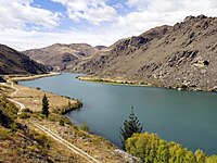
Lake Dunstan with Kawarau Arm (left) and Dunstan Arm (right)

Lake Dunstan - Kawarau Arm with Blich to the Carrick Range

Information plate at the view point of the village of Cromwell
.jpg)


.jpg)
.jpg)
.jpg)
.jpg)
See also
literature
- Robert S. Yeats : Tectonic map of Central Otago based on Landsat imagery . In: New Zealand Journal of Geology and Geophysics . Volume 30, Issue 3 , 1987, pp. 261–271 , doi : 10.1080 / 00288306.1987.10552621 (English, online [PDF; 3.8 MB ; accessed on June 14, 2018]).
Web links
- John E. Martin : Clyde dam . In: Te Ara - the Encyclopedia of New Zealand . Ministry for Culture & Heritage , March 11, 2010, accessed on June 20, 2018 (English, two photos of part of the lake before and after the damming).
- Clyde Dam - Fact Sheet . Contact Energy, August 23, 2017,accessed June 20, 2018.
- Clarence R. Allen, Lloyd S. Cluff : Active Faults in Dam Foundations: an Update . (PDF 87 kB) Indian Institute of Technology, Kanpur , 2000, p. 4 , accessed on June 20, 2018 (English).
Individual evidence
- ↑ a b c d e Clyde Dam - Fact Sheet . Contact Energy , accessed June 20, 2018 .
- ↑ a b Information board at the viewpoint on the lake near the town of Cromwell, photographed and accessed on February 12, 2017
- ↑ a b c d Topo maps . Land Information New Zealand , accessed June 20, 2018 .
- ↑ a b Coordinates and longitudes were determined using Goggle Earth Pro Version 7.3.1.4507 on June 20, 2018
- ^ Yeats : Tectonic map of Central Otago based on Landsat imagery . 1987, p. 266 .
- ^ Clarence R. Allen, Lloyd S. Cluff : Active Faults in Dam Foundations: an Update . (PDF 87 kB) Indian Institute of Technology, Kanpur , 2000, p. 4 , accessed on June 20, 2018 (English).
- ↑ a b Shane Gilchrist : Reflections on Lake Dunstan . Otago Daily Times , January 2, 2010, accessed June 20, 2018 .