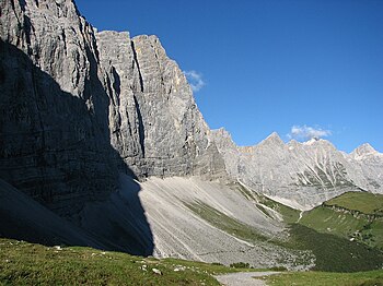
Laliderer walls

The Laliderer walls are a consecutive row of almost vertical rock faces in the Hinterautal-Vomper chain in the center of the Karwendel and one of the most famous climbing areas in the Northern Limestone Alps . The walls are about 900 meters high and reach just below the summit areas of Lalidererspitze ( 2588 m above sea level ) and Grubenkarspitze ( 2663 m above sea level ). The highest point - known as the Laliderer Wall - is 2620 m above sea level. A. (according to other information at 2615 m above sea level ), a little to the east of it the Dreizinkenspitze ( 2603 m above sea level ).
Some challenging climbing routes ( grades around IV to VIII) lead through the dark north walls, which are not quite as smooth from close up as they appear from below. To protect against frequent weather changes in the waterless summit regions, a modern bivouac box ( Karl-Schuster-Bivouac ) was built in the 1990s about 50 meters below the summit of the Lalidererspitze .
A well-traveled hiking trail - which runs from Scharnitz through the Karwendeltal via the Falkenhütte to the Großer Ahornboden and on to the Achensee - leads directly past the foot of the Lalidererwände. On beautiful summer days you can hear a kind of singing ringing, the origin of which is initially unclear to the mountain hiker. It is the multilayered mixed echo of the sheep and cow bells from the Lalidersalm .
literature
- Heinrich Klier, Fritz March: Karwendel Mountains. Bergverlag Rother , Munich 1984. ISBN 3-7633-1200-5 .
Individual evidence
- ↑ http://www.geoland.at/ ÖK50
- ↑ Karwendel Mountains Alpine Club Guide, margin number 1455
Web links
Coordinates: 47 ° 23 ′ 21 ″ N , 11 ° 30 ′ 30 ″ E
