
Long mile

Long meil (often just mile ) is the regional name for a 6.5-kilometer section of federal highway 49 between the Obertiefenbach -West exit and the Limburg -Nord junction of federal motorway 3 .
history
"Lange Meil" originally referred to the Altstrasse , which led from Limburg to shortly after Steinbach and where it forked into a branch to Herborn and Dillenburg and another to Rennerod and Siegen . There was a customs house near Ahlbach . Since the route was almost exactly one Prussian mile (7,532.50 meters) long and did not touch any locality, the pedestrians of the 19th century coined the name Lange Meil , which has survived to this day despite the changed use.
During construction work in 1816, the course of the "Meil" was transferred to the current route of the B 49 between Limburg and Obertiefenbach. The old name of the road from Limburg via Ahlbach to Steinbach has been transferred to the federal highway Limburg - Ahlbach - Obertiefenbach.
Long mile today
Today's Lange Meil only shows a slight bend near Ahlbach and otherwise runs completely straight in both sections. The northern section from the curve to Obertiefenbach was aligned with the top of the steeple of the parish church of St. Agidius .
The route is built similar to a motorway, with structurally separate directional lanes and two lanes per direction of travel. The speed is limited to 100 km / h (70 km / h on the motorway) due to the risk of accidents. The last three kilometers have a steady gradient in the direction of Limburg.
From Ahlbach to Limburg, the route is also used by federal highway 54 .
literature
- Josef Schmidt: The Long Meil . In: Yearbook for the Limburg-Weilburg district 1996 . The district committee of the district of Limburg-Weilburg, Limburg-Weilburg 1995, p. 61-62 .
photos

Lange Meil, direction Limburg (seen from Ahlbach)
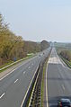
Lange Meil, direction Obertiefenbach (seen from Ahlbach)

Lange Meil, bend near Ahlbach (seen from Obertiefenbach)
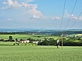
View from the Lange Meil near Ahlbach southeast over the Lahn valley to the Taunus


Individual evidence
- ↑ Georg Wagner : Obertiefenbach in his past . Obertiefenbach community, Wiesbaden-Dotzheim 1954, p. 86-92 .