Lanterna
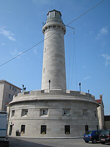
Lanterna (German lantern or lighthouse ) is the former lighthouse of the northern Italian city of Trieste in the old port , which was in operation from 1833 to 1969. It was part of a project initiated by the Trieste Chamber of Commerce with over a dozen lighthouses on the Adriatic coast , which were intended to increase the safety of shipping in the first half of the 19th century.
history
The 33 meter high lighthouse is based on a plan by Karl von Zinzendorf, who was Governor of Trieste from 1776 to 1882 . In 1831 it was built according to the design of the German architect Matteo Pertsch . Its foundation rests on the Scoglio dello Zucco rock , which the Romans used to warn ships about with a signal system. It is part of the Mole Fratelli Bandiera (formerly Molo di Santa Teresa ), which forms the eastern end of the old port of Trieste ( Porto Vecchio ) and whose construction was initiated by Maria Theresa between 1744 and 1769 . When it was put into operation on February 11, 1833, it was the only light signal on the Gulf of Trieste , which stretched 16 nautical miles and was generated by "a light device according to Fresnel's system with a large moderator lamp and two concentric wicks". Using a system that was new at the time, an intermittent light was emitted with an interruption frequency of 30 seconds. From 1860 it worked on a petroleum basis and since 1926 it was electric. The lighting technology is now in the Naval Museum of La Spezia . In 1946, the Lanterna received an outer skin in the same color scheme with horizontal stripes as is common for lighthouses, but this was removed in 1955 and the original colors were restored.
With the commissioning of the new Faro della Vittoria lighthouse (Lighthouse of Victory) on the opposite side of the Gulf of Trieste, in the Gretta district, in 1927, the Lanterna lighthouse lost its importance for shipping, but it was not decommissioned until 1969. Today the tower serves as normal harbor lighting.

More signals and indicators from the lighthouse
Flags and bullets were used by the lighthouse to show the ship's movements in the harbor (illustration), and a cannon shot fired from the base of the lighthouse announced the noon hour . The barometer reading, which was updated several times a day, could be read on a scale on the lake side .
Defense system
The lighthouse rests on a circular base with a circumference of 60 meters, a so-called "Maximilian Tower" with two rows of loopholes, which allowed for all-round defense of 360 °. Its construction went back to Archduke Maximilian Joseph von Österreich-Este , who followed the English model of the Martello Tower . In addition to the lighthouse base, there were three other Maximilian towers in Trieste: the Fort of Sanza and two more towers at the Santa Teresa hospital.
Others
- The lighthouse was accessible in the 19th century with "a permit from the command station".
- Together with a paddle steamer in rough seas, the Lanterna graced the title pages of the Almanac Illustrated Family Book published by Österreichischer Lloyd from 1850 to 1865 .
- A model of the lighthouse is in the Museum of the Trieste Chamber of Commerce (Museo Commerciale di Trieste) .
See also
literature
- Alessandro Paglia (Ed.): La Lanterna. Trieste sono io . Assicurazioni Generali, Trieste 1997, 116 pp.
Individual evidence
- ↑ a b See the information and the illustration of the Museum of the Trieste Chamber of Commerce online .
- ^ Building description and plans of the lighthouse from the Allgemeine Bauzeitung 1838, pp. 239, 240 and CCXVII, at Anno .
- ↑ a b c Compare the website Trieste segreta .
- ^ Wenzel Karl Wolfgang Blumenbach: Latest painting of the Austrian monarchy. Second part. On commission from Anton Doll, Vienna 1832, p. 164
- ↑ a b August Mandl: From Vienna to Trieste, along with journeys from Bodenbach, Olmütz, Krakow, Linz, Pesth to Vienna and from Trieste to Venice. Travel guide for all stations of the KK Priv. Südbahn from 1858 (2nd edition). Literary and artistic department of Österreichischer Lloyd , Triest 1860, p. 165
- ^ Horst Friedrich Mayer, Dieter Winkler: Austria was in all ports - the Austro-Hungarian merchant navy . Verlag der Österreichische Staatsdruckerei, Vienna 1987, p. 24
- ↑ Compare the entries in old travel guides, such as Baedeker's Austria from 1873.
- ^ The Austrian Lloyd and the Territory Along Its Route. Official Guide-Book of the Steamship Company. Istria, Dalmatia, Herzegovina and Bosnia . Rudolf M. Rohrer, Vienna-Brünn-Leipsic o. J. [1901], p. 34
Coordinates: 45 ° 38 ′ 56.9 " N , 13 ° 45 ′ 21.7" E


