
Schradenau

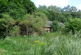
- Dilapidated buildings at the Vorwerk (2017)


Schradenau , sometimes also called Lappige Jacket , is a former Vorwerk in the southern Brandenburg lowland landscape of Schraden in the Elbe-Elster district . The old Vorwerk, which was also referred to as the eastern entrance gate to Schraden in an article in the Lausitzer Rundschau in 2012, is located in the northeast of the municipality of Schraden and can be found three hundred meters east of the state road L 63, with which it is only accessible via an unpaved path connected is.
Since Schradenau is not yet recorded in an original table by Woedtke from 1841 and other map series before this point in time, it is assumed that the Vorwerk was only created after the separation in Schraden as a result of the regulation of the Black Elster . The Vorwerk got its name after the lowland landscape surrounding the area. Schradenau, like the Vorwerk Schönau near Großthiemig , appears in topographical maps for the first time in a separation map in 1854. It belonged as the Vorwerk Rothes Buschhaus to Großkmehlen and on the basis of which from 1874 to the District Großthiemig the circle Liebenwerda .
In 1929 Schradenau then merged into the newly formed Schraden community. Due to its poor condition, it has also been known as the Lappige Jacket since around 1945 and is now also recorded under this name in topographic maps. Until March 4, 2014, the settlement under the name Lappigejacket was an officially designated residential area of the Schraden municipality, after which it was deleted from the district directory. Except for a stable house , which is inhabited or still managed, the other buildings of the Vorwerk are largely abandoned to decay.
A few hundred meters northwest of the former Vorwerk there is another place to live on the Schradenau path of the same name , which is now largely overgrown .

Footnotes and individual references
- ↑ Torsten Richter: About the sharp "jungle girl" from Elsterau - Vorwerk once stood on the Black Elster between Biehlen and Ruhland in Lausitzer Rundschau , March 10, 2012.
- ^ A b c Luise Grundmann, Dietrich Hanspach (author): Der Schraden. A regional study in the Elsterwerda, Lauchhammer, Hirschfeld and Ortrand area . Ed .: Institute for Regional Geography Leipzig and the Saxon Academy of Sciences in Leipzig. Böhlau Verlag, Cologne / Weimar / Vienna 2005, ISBN 3-412-10900-2 , p. 120 - 121 .
- ^ Emilia Crome: The place names of the Bad Liebenwerda district . Akademie Verlag , Berlin 1968, p. 87 .
- ↑ a b Official Gazette of the Government of Merseburg: 1874 . S. 14 .
- ↑ Community and district directory of the state of Brandenburg. Land surveying and geographic base information Brandenburg (LGB), accessed on June 17, 2020.
- ↑ As of August 2017.
Web links
Coordinates: 51 ° 26 ′ 56 " N , 13 ° 42 ′ 55.7" E