
Largue (Ill)
| Largue | ||
 The largue in Dannemarie |
||
| Data | ||
| Water code | FR : A11-0200 | |
| location |
Sundgau
|
|
| River system | Rhine | |
| Drain over | Ill → Rhine → North Sea | |
| source | on Glaserberg near Oberlarg near the border with Switzerland 47 ° 27 ′ 20 ″ N , 7 ° 14 ′ 20 ″ E |
|
| Source height | 500 m | |
| muzzle | at Illfurth in the Ill Coordinates: 47 ° 39 '46 " N , 7 ° 14' 22" E 47 ° 39 '46 " N , 7 ° 14' 22" E |
|
| Mouth height | 258 m | |
| Height difference | 242 m | |
| Bottom slope | 4.7 ‰ | |
| length | 51 km | |
| Catchment area | 277.1 km² | |
| Discharge A Eo : 277.1 km² at the mouth |
MQ 1971–1990 Mq 1971–1990 |
3.46 m³ / s 12.5 l / (s km²) |
 The composed source |
||
The Largue (Eng .: Larg ) is a 51 km long tributary of the Ill in the Sundgau landscape of the Grand Est region , France .
Surname
The name of the river is derived from the Latin larga .
geography
course
The Largue rises at about 500 m altitude on the Glaserberg near Oberlarg near the border with Switzerland and flows into the Ill at Illfurth at 258 m altitude .
Tributaries
- Laltriff ( left ), 1.4 km
- Goutte ( left ), 1.3 km
- Ribersmattenbach ( left ), 3.7 km
- Grumbach ( right ), 11.6 km
- Babersenbach ( left ), 4.6 km
- Largitzenbach ( right ), 13.1 km
- Halsbach ( right ), 3.0 km
- Krebsbach ( left )
- Elbbaechlein ( left ), 5.8 km
- Traubach ( left ), 9.8 km
- Soultzbach ( left ), 16.7 km
- Allmendgraben ( right ), 5.2 km
- Grengelgraben ( right ), 1.3 km
- Krebsbach ( left ), 14.7 km
- Trendlingergraben ( left ), 6.9 km
Hydrology
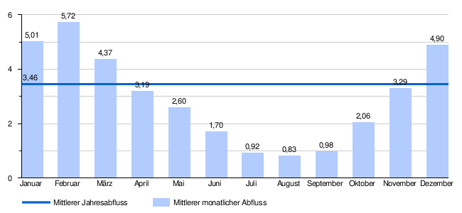
At the confluence of the Largue in the Ill, the mean natural flow rate (MQ) is 3.46 m³ / s; the catchment area here covers 277.1 km². It slightly exceeds the Ill, which leads 3.24 m³ / s at the mouth and drains a catchment area of 339.4 km².
At the Spechbach-le-Bas gauge, the average annual runoff of the Largue was calculated over a period of 41 years (1969–2009) . The catchment area at this point corresponds to about 86% of the entire catchment area of the river with 239 km².
The flow rate fluctuates quite strongly over the course of the year. The highest water levels are measured between December and March. The flow rate reached its peak in February at 5.72 m³ / s. From April on, the discharge decreases month by month and reaches its lowest level in August with 0.83 m³ / s, after which it increases again from month to month.
The monthly mean discharge (MQ) of the Largue in m³ / s, measured at the hydrological station Spechbach-le-Bas.
Data calculated from the values for the years 1969–2009
Individual evidence
- ↑ Largue at SANDRE (French)
- ↑ a b c see web link: Débits caractéristiques de la Largue
- ↑ Banque Hydro - A1150200 La Largue à Spechbach-le-Bas (menu item: Synthèse)
Web links
- Débits caractéristiques de la Largue (débits naturels reconstitués) (French; PDF; 17 kB), accessed on January 5, 2016