
Oberlarg
| Oberlarg | ||
|---|---|---|
.svg)
|
|
|
| region | Grand Est | |
| Department | Haut-Rhin | |
| Arrondissement | Altkirch | |
| Canton | Altkirch | |
| Community association | Sundgau | |
| Coordinates | 47 ° 27 ' N , 7 ° 14' E | |
| height | 482-740 m | |
| surface | 8.21 km 2 | |
| Residents | 138 (January 1, 2017) | |
| Population density | 17 inhabitants / km 2 | |
| Post Code | 68480 | |
| INSEE code | 68243 | |
 town hall |
||

Oberlarg is a French commune with 138 inhabitants (as of January 1, 2017) in the Haut-Rhin department in the Grand Est region ( Alsace until 2015 ). It belongs to the community association Sundgau . The castle ruins and courtyard of the Château de Morimont ( Burg Mörsberg ) are also located in the municipality .
geography
Oberlarg is located in a hollow in the northern Jura in the south of Alsace . The Largue rises in the Mulde , in the catchment area of which Oberlarg is largely located.
Watershed
In Oberlarg is the intersection of the catchment areas of the Rhenish tributaries Ill ( Largue ) and Birs ( Lützel ) on the one hand and the Rhone ( Allaine ) on the other hand, west of Les Ebourbettes on an unnamed mountain (727 m), near the border with Charmoille and Lucelle.
Neighboring communities
The areas of the following municipalities border on the municipality of Oberlarg: Liebsdorf in the north, Winkel in the east, Lucelle in the southeast, La Baroche (Switzerland) in the south, Levoncourt in the southwest and Courtavon in the west.
history
From 1871 until the end of the First World War , Oberlarg belonged to the German Empire as part of the realm of Alsace-Lorraine and was assigned to the Altkirch district in the Upper Alsace district .
Population development
| year | 1910 | 1962 | 1968 | 1975 | 1982 | 1990 | 1999 | 2006 | 2017 |
| Residents | 225 | 162 | 174 | 157 | 148 | 146 | 143 | 146 | 138 |

St. Martin Church
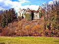
Castle ruins Mörsberg ( Morimont )

school


literature
- Le Patrimoine des Communes du Haut-Rhin. Flohic Editions, Volume 1, Paris 1998, ISBN 2-84234-036-1 , pp. 432-435.
See also
Web links
Individual evidence
- ^ National map of Switzerland, sheets 1065, 1066, 1085 and 1086.
- ^ Municipal directory Germany 1900 - Altkirch district