Werentzhouse
| Werentzhouse | ||
|---|---|---|

|
|
|
| region | Grand Est | |
| Department | Haut-Rhin | |
| Arrondissement | Altkirch | |
| Canton | Altkirch | |
| Community association | Sundgau | |
| Coordinates | 47 ° 31 ' N , 7 ° 21' E | |
| height | 367-471 m | |
| surface | 4.50 km 2 | |
| Residents | 544 (January 1, 2017) | |
| Population density | 121 inhabitants / km 2 | |
| Post Code | 68480 | |
| INSEE code | 68363 | |
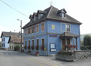
 Mairie Werentzhouse |
||
Werentzhouse (German Werenzhausen ) is a French commune with 544 inhabitants (as of January 1, 2017) in the Haut-Rhin department in the Grand Est region (until 2015 Alsace ). It belongs to the arrondissement Altkirch , the canton Altkirch and the municipality association Sundgau .
geography
The community is located on the upper Ill in the southern Sundgau and is about 17 kilometers from Altkirch and 20 kilometers from Basel .
Neighboring communities of Werentzhouse are Muespach in the northeast, Fislis in the southeast, Bouxwiller in the southwest and Durmenach in the northwest.
The community owned a train station on the Altkirch – Ferrette railway from 1892. Passenger traffic was shut down in 1953. The last freight train ran in 1968, after which the line from Hirsingue was closed. The station building ⊙ has been preserved and is now used as a residential building.
Population development
| year | 1962 | 1968 | 1975 | 1982 | 1990 | 1999 | 2007 | 2017 |
| Residents | 354 | 357 | 401 | 421 | 462 | 555 | 587 | 544 |
literature
- Le Patrimoine des Communes du Haut-Rhin. Flohic Editions, Volume 1, Paris 1998, ISBN 2-84234-036-1 , pp. 452-454.

