Largitz
| Largitz | ||
|---|---|---|

|
|
|
| region | Grand Est | |
| Department | Haut-Rhin | |
| Arrondissement | Altkirch | |
| Canton | Masevaux | |
| Community association | Sud Alsace Largue | |
| Coordinates | 47 ° 34 ' N , 7 ° 11' E | |
| height | 366-431 m | |
| surface | 5.60 km 2 | |
| Residents | 314 (January 1, 2017) | |
| Population density | 56 inhabitants / km 2 | |
| Post Code | 68580 | |
| INSEE code | 68176 | |
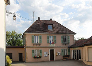
 Mairie Largitzen |
||
Largitzen ( Larga in antiquity) is a French commune with 314 inhabitants (as of January 1, 2017) in the Haut-Rhin department in the Grand Est region (until 2015 Alsace ).
geography
In the north and in the east, the municipality has a share of an almost 50 km² forest area in which there are numerous small lakes. The Largitzenbach , a tributary of the Largue , separates the core town of Largitzen from the district of Luffendorf . Neighboring communities of Largitzen are: Hindlingen and Hirtzbach in the north, Hirsingue and Heimersdorf in the east, Bisel , Seppois-le-Bas and Seppois-le-Haut in the south and Ueberstrass and Friesen in the west.
Population development
| year | 1962 | 1968 | 1975 | 1982 | 1990 | 1999 | 2007 | 2016 |
| Residents | 224 | 237 | 243 | 263 | 264 | 276 | 288 | 312 |
literature
- Le Patrimoine des Communes du Haut-Rhin. Flohic Editions, Volume 1, Paris 1998, ISBN 2-84234-036-1 , pp. 578-580.
Web links
Commons : Largitzen - collection of images, videos and audio files


