
Manspach
| Manspach | ||
|---|---|---|
.svg)
|
|
|
| region | Grand Est | |
| Department | Haut-Rhin | |
| Arrondissement | Altkirch | |
| Canton | Masevaux | |
| Community association | Sud Alsace Largue | |
| Coordinates | 47 ° 37 ′ N , 7 ° 6 ′ E | |
| height | 304-387 m | |
| surface | 5.33 km 2 | |
| Residents | 560 (January 1, 2017) | |
| Population density | 105 inhabitants / km 2 | |
| Post Code | 68210 | |
| INSEE code | 68200 | |
 Mairie Manspach |
||

Manspach is a French commune with 560 inhabitants (as of January 1, 2017) in the Haut-Rhin département in the Grand Est region (until 2015 Alsace ) and is a member of the Sud Alsace Largue community of communes .
The community is located in Sundgau , south of Dannemarie and north of Altenach . A railway viaduct leads north of the village over the Largue - the motif for the municipal coat of arms .
history
From 1871 until the end of the First World War , Manspach belonged to the German Empire as part of the realm of Alsace-Lorraine and was assigned to the Altkirch district in the Upper Alsace district .
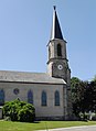
St. Leodegar Church

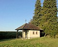
Cemetery chapel
Chapel of Our Lady of the Fields


Population development
| year | 1910 | 1962 | 1968 | 1975 | 1982 | 1990 | 1999 | 2007 | 2016 |
| Residents | 395 | 325 | 327 | 401 | 401 | 424 | 499 | 528 | 573 |
Economy and Transport
Agriculture and small businesses are important branches of industry . Départementsstrasse D 103 ( Thann - Delle ) runs through Manspach . The next station of SNCF is in the neighboring town of Dannemarie . It is served by line 14 ( Mulhouse - Belfort ) of the regional TER Alsace railway company.
literature
- Le Patrimoine des Communes du Haut-Rhin. Flohic Editions, Volume 1, Paris 1998, ISBN 2-84234-036-1 , pp. 318-320.