
Eteimbes
| Eteimbes | ||
|---|---|---|
.svg)
|
|
|
| region | Grand Est | |
| Department | Haut-Rhin | |
| Arrondissement | Altkirch | |
| Canton | Masevaux | |
| Community association | Sud Alsace Largue | |
| Coordinates | 47 ° 42 ' N , 7 ° 3' E | |
| height | 340-412 m | |
| surface | 4.96 km 2 | |
| Residents | 380 (January 1, 2017) | |
| Population density | 77 inhabitants / km 2 | |
| Post Code | 68210 | |
| INSEE code | 68085 | |
 Mairie Eteimbes |
||

Eteimbes ( German Welschsteinbach ) is a French commune with 380 inhabitants (as of January 1, 2017) in the Haut-Rhin department in the Grand Est region (until 2015 Alsace ) and is a member of the Sud Alsace Largue community association .
geography
The name of the place was given by the "Steinbach", which flows through the municipality. Eteimbes is located on the western edge of the Alsace region and on the northwest edge of the Sundgau , only about three kilometers east of the Bourgogne-Franche-Comté region , 23 kilometers southwest of Mulhouse . In the municipality, on the Haut Bois ridge , two watershed lines meet . The Steinbach flows towards the Rhineland and the Rapène flows towards the Rhône Valley .
history
From 1324 to 1648 Eteimbes was a fief of the Upper Austrian Seigneurs von Thann . Accordingly, the village was mentioned in documents in 1331 and 1576 as "Steinbach". In 1779 it was called Estambes .
In 1793 Eteimbes received in the course of the French Revolution (1789-1799) the status of a municipality and in 1801 the right to local self-government.
In 1871 Alsace was annexed by the German Empire . Eteimbes belonged within the realm of Alsace-Lorraine to the Altkirch district in the Lower Alsace district and lay on the former border between Germany and France. About twenty boundary stones in the municipality are evidence of this. From 1919 the municipality belonged again to France.
Population development
| year | 1910 | 1962 | 1968 | 1975 | 1982 | 1990 | 1999 | 2007 | 2016 |
| Residents | 207 | 82 | 105 | 123 | 148 | 232 | 280 | 306 | 383 |
Attractions
The parish church is dedicated to Saint Pantalus ( Saint Pantale ). The bell tower was rebuilt in 1953. The chapel sacré coeur de Jésus ( Sacred Heart of Jesus ) was built in 1870.
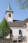
St. Pantalus Church

Sacred Heart Chapel


economy
The image of the community is characterized by pastures, fields and forests. In the 1960s the importance of agriculture as a branch of business predominated. Over time, houses were built between the farms. Many residents now live in Eteimbes, but work in Mulhouse.
literature
- Le Patrimoine des Communes du Haut-Rhin. Flohic Editions, Volume 1, Paris 1998, ISBN 2-84234-036-1 , pp. 304-306.
Web links
- Eteimbes on the website of the CC Porte d'Alsace (French)
- Eteimbes on cartesfrance.fr (French)
Individual evidence
- ↑ Eteimbes on quid.fr ( Memento of the original from September 20, 2009 in the Internet Archive ) Info: The archive link was inserted automatically and has not yet been checked. Please check the original and archive link according to the instructions and then remove this notice. (French) Retrieved February 2010
- ^ M. Georges Stoffel: Dictionnaire Topographique du Département du Haut-Rhin Comprenant les Noms de Lieu Anciens Et Moderns . BiblioBazaar, 2009, ISBN 978-1-115-45683-8 , pp. 46 ( reprinted in Google Books [accessed December 4, 2009]). (French)
- ^ Eteimbes on Cassini.ehess.fr (French). Retrieved December 4, 2009
- ^ Municipal directory Germany 1900 - Altkirch district