
Tagolsheim
| Tagolsheim | ||
|---|---|---|
.svg)
|
|
|
| region | Grand Est | |
| Department | Haut-Rhin | |
| Arrondissement | Altkirch | |
| Canton | Altkirch | |
| Community association | Sundgau | |
| Coordinates | 47 ° 39 ′ N , 7 ° 16 ′ E | |
| height | 262-367 m | |
| surface | 3.19 km 2 | |
| Residents | 928 (January 1, 2017) | |
| Population density | 291 inhabitants / km 2 | |
| Post Code | 68720 | |
| INSEE code | 68332 | |

Tagolsheim is a French commune with 928 inhabitants (as of January 1, 2017) in the Haut-Rhin department in the Grand Est region (until 2015 Alsace ). It belongs to the arrondissement Altkirch , the canton Altkirch and the municipality association Sundgau .
geography
The municipality of Tagolsheim is located in the Sundgau , south of Mulhouse and northeast of Altkirch in the valley of the river Ill . Tagolsheim has a train station on the Paris – Mulhouse line , where the TER Alsace and TER Franche-Comté trains stop .
Neighboring communities of Tagolsheim are Illfurth in the north, Luemschwiller in the east, Walheim in the south, Aspach in the southwest and Heidwiller in the west.
history
The village square used to be on the Ill . As part of a soil research, felled trees that had grown into the ground were found there. Among them was a linden tree .
Population development
| year | 1962 | 1968 | 1975 | 1982 | 1990 | 1999 | 2006 | 2014 |
| Residents | 440 | 460 | 625 | 698 | 691 | 662 | 632 | 844 |
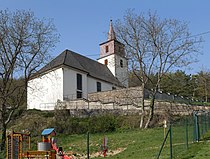
St. Leodegar Church

town hall


literature
- Le Patrimoine des Communes du Haut-Rhin. Flohic Editions, Volume 1, Paris 1998, ISBN 2-84234-036-1 , pp. 82-83.
Web links