
Jettingen (Haut-Rhin)
| Jettingen | ||
|---|---|---|
.svg)
|
|
|
| region | Grand Est | |
| Department | Haut-Rhin | |
| Arrondissement | Altkirch | |
| Canton | Altkirch | |
| Community association | Sundgau | |
| Coordinates | 47 ° 36 ' N , 7 ° 22' E | |
| height | 338-431 m | |
| surface | 6.30 km 2 | |
| Residents | 502 (January 1, 2017) | |
| Population density | 80 inhabitants / km 2 | |
| Post Code | 68130 | |
| INSEE code | 68158 | |
 Mairie Jettingen |
||

Jettingen is a French commune with 502 inhabitants (as of January 1, 2017) in the Haut-Rhin department in the Grand Est region (until 2015 Alsace ). It belongs to the arrondissement Altkirch , the canton Altkirch and the municipality association Sundgau .
geography
The municipality of Jettingen is located in the Sundgau , about twelve kilometers east of Altkirch and 25 kilometers south of Mulhouse .
Neighboring communities of Jettingen are Zaessingue in the north, Helfrantzkirch in the east, Berentzwiller in the south, Steinsoultz in the southwest and Franconia in the west.
Départementsstrasse D419 ( Belfort - Basel ) runs through the municipality .
history
From 1871 until the end of the First World War , Jettingen belonged to the German Empire as part of the realm of Alsace-Lorraine and was assigned to the Altkirch district in the Upper Alsace district .
Population development
| year | 1910 | 1962 | 1968 | 1975 | 1982 | 1990 | 1999 | 2006 | 2016 |
| Residents | 428 | 391 | 430 | 383 | 394 | 470 | 502 | 508 | 506 |
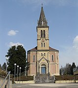
Sacred Heart Church in Jettingen
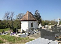
Chapel of St. Leodegar


literature
- Le Patrimoine des Communes du Haut-Rhin. Flohic Editions, Volume 1, Paris 1998, ISBN 2-84234-036-1 , pp. 67-70.