Beşparmak Dağları
| Beşparmak Dağları | |
|---|---|
|
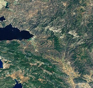
landsat - image of Beşparmak Dağları and Lake Bafa |
|
|
Lake Bafa with Herakleia on the Latmos |
|
| Highest peak | Tekerlek Dağı ( 1374 m ) |
| location | Province Muğla , Turkey |
| Coordinates | 37 ° 31 ' N , 27 ° 35' E |
The Beşparmak Dağları ( German five-finger mountains , also Batı Menteşe Dağları , in the ancient Latmos Mountains ) are a mountain range in the Turkish province of Muğla . It begins northeast of Lake Bafa at the Büyük Menderes valley and stretches southeast to east of Milas , where it merges into the Marçal Dağları. In the east lies the valley of the Çine Çayı, in the west the Bafa lake and the mountain range of the İlbir Dağı. The highest point is the Tekerlek Dağı, the ancient Latmos, near the east bank of the lake with 1374 m.
history
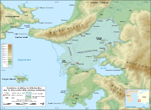
As can be seen from the rock paintings in the Latmos Mountains , which Anneliese Peschlow discovered together with Volker Höhfeld in 1994, the area was already settled in the Chalcolithic Age. At least parts of the Latmos belonged to the Hittite Empire in the 2nd millennium BC. BC to the Kingdom of Mira , as evidenced by the rock inscription on Suratkaya, also discovered by Peschlow . In ancient times the mountains belonged to the Caria region . Until the fourth century AD, it was still by the sea, as today's Bafa Lake was connected to the Aegean Sea as the Latmian Gulf . Only then was the bay cut off from the open sea by the deposits of the meander (Büyük Menderes). The ancient city of Herakleia on Latmos at the eastern end of Lake Bafa was thus in the fourth century BC. The border fortress on the northern border of the rulership of Halicarnassus under King Maussolos In Latmos lies the Carian sanctuary Labraunda , which also belonged to Halicarnassus, at an altitude of 700 m , on the south-western slope the place Euromos . Strabo mentions the mountain and the city of Herakleia in his Geographika. In his opinion, it is the mountain that is mentioned in Homer's Iliad as Φθειρῶν ὄρος ( Mount of the Phthirs , Pinienkernberg or Fichtenberg , depending on the translation). In Byzantine times, the mountains were a retreat for Christian monks and hermits, as evidenced by the Stylos Monastery, where the last monks vainly resisted the Seljuks at the end of the 13th century . After that the mountains were deserted until the Turkish nomads began to graze their herds here.
geology
The mountain , consisting of the Menderes massif , granitic intrusions and metamorphic slates with embedded marble, rises in the form of jagged and pinnacles, which is what gave the Turkish name. The forms that occur also include caves that were used by hermits as dwellings, as well as weathered wool sacks and plaque formation. When the gneiss is weathered, quartz sand is produced, which is washed down to the lake and is deposited there in fine-grain quartz dunes.
Flora and fauna
The Beşparmak Dağları have only sparse vegetation in places. It consists mostly of low bushes of Kermes oaks that are heavily bitten by goats . At higher elevations, remains of pine forests and extensive pine forests can be found, from which pine nuts are extracted. The residents cultivate olive trees on many slopes and flat areas and keep bee colonies for honey production.
Hardune can be found in the ruins, on the lakeshore and in the olive groves, while the snake- eye lizard (Orphisops elegans) and the Örtzen lizard, which only occurs in Turkey, are found on the sparsely vegetated soil . Porcupines are found at higher elevations and there is a small population of brown bears .
Ecological problems
For more than a quarter of a century, efforts have been made to have parts of the Beşparmak mountainous area declared a national park in order to prevent further and final destruction of valuable cultural and historical relics in one of the most attractive natural landscapes in Turkey. It is primarily the desire of the private and state Turkish mining industry to extract raw materials for the ceramics industry that threatens the ecology of the mountains. As early as the mid-1990s, scientists approached UNESCO with an effort to put the archaeological finds and the natural beauty of the Latmos under protection. The success was limited: in 1994 only a 12,281 hectare shoreline around the 60 km² Bafa Lake and the neighboring meander delta as part of the “Aydın Nature Park” were declared the Bafa Gölü Tabiat Park ı landscape protection area.
In 1984, the Latmos began building feldspar, quartz and marble mines, and mining accelerated significantly from 2004 to 2014. From 1984 to 2018, but above all in the last 14 years, a total of 3800 ha of land in Latmos was destroyed by mining activities, 1500 ha by feldspar quartzite quarries, 1390 ha by marble quarries and 900 ha by lignite mining. In the last few years alone, when mining has increased sharply due to incentives for mining and tax cuts, seven new feldspar quarries for raw materials for the glass, ceramics, welding electrodes and paint industries were opened in this region by 2012. According to news in Turkish newspapers, an environmental impact assessment regarding the expansion of the capacity of feldspar, quartz and quartzite mines in Latmos found that all the villages in the region are facing serious problems of all kinds.
The first massive demonstrations against overexploitation of the natural and cultural assets of the Latmos began under the motto “Save the Latmos” in November 2012. Despite violent protests from the population, environmental associations, national and international representatives of science and the Turkish health service, despite repeated applications UNESCO and Turkish government agencies, and despite targeted scientific studies that reveal the rapid progress of environmental degradation through mining activities, a sustainable mining stop in Latmos has not yet been achieved.
literature
- Anneliese Peschlow: The Latmos. An unknown mountain landscape on the Turkish west coast . von Zabern, Mainz 1996 ( Zabern's illustrated books on archeology / special editions of the ancient world ), ISBN 3-8053-1994-0 .
- Anneliese Peschlow: Early human images . The prehistoric rock paintings of the Latmos Mountains (Western Turkey) . von Zabern, Mainz 2003, ISBN 3-8053-3001-4 .
- Volker Höhfeld (Hrsg.): Herakleia - city and landscape of the Latmos. A historical-geographical guide through the Latmos Mountains and its surroundings. - Global Studies Working Papers of the Tübingen Institute of Geography 37, Tübingen 2017.
- Hans Lohmann (Ed.): Field research in the Latmos. Research in the area around Herakleia on the Latmos . Asia Minor Studies 93, Habelt-Verlag, Bonn 2019, ISBN 978-3-7749-4214-1 .
Web links
- German Archaeological Institute - Latmos Region
- Early Human Images - The early rock paintings of the Latmos Mountains in western Turkey
Individual evidence
- ↑ Höhfeld, Volker: Herakleia - City and Landscape of Latmos: a historical-geographical guide through the Latmos Mountains and its surroundings . In: Volker Höhfeld (Ed.): Global Studies Working Papers . tape 37 . Tübingen Institute of Geography, Tübingen 2017, p. 8 ( worldcat.org [accessed August 9, 2020]).
- ↑ Volker Höhfeld: Herakleia - city and landscape of the Latmos. A historical-geographical guide through the Latmos Mountains and its surroundings . In: Volker Höhfeld (Ed.): Global Studies Working Papers . tape 37 . Institute of Geography, Tübingen 2017, p. 8 .
- ^ Volker Höhfeld: Cultural landscape change in the Latmos (Beşparmak, Southwest Turkey). A contribution to genetic settlement research in a mountainous region in Western Anatolia. In: Hans Lohmann (Ed.): Asia Minor Studies . tape 93 . Habelt-Verlag, Bonn 2019, ISBN 978-3-7749-4214-1 , pp. 3 f .
- ^ Frank Kolb: Chora and Polis . Oldenbourg Wissenschaftsverlag, 2004 p. 328 ISBN 978-3-486-56730-4 on GoogleBooks
- ↑ Marianne Mehling (Ed.): Knaurs Kulturführer in Farbe Turkey . Droemer-Knaur, 1987, ISBN 3-426-26293-2 , p. 236.
- ^ Geographika XIV 1.8 at GoogleBooks
- ↑ Homer, Iliad, II 868 at GoogleBooks
- ^ Frank Rainer Schreck: Turkey - the west coast . DuMont Reiseverlag, 2005 pp. 173–175 ISBN 978-3-7701-6026-6 at GoogleBooks
- ↑ Volker Höhfeld: Herakleia - city and landscape of the Latmos. A historical-geographical guide through the Latmos Mountains and its surroundings. In: Volker Höhfeld (Ed.): Global Studies Working Papers . tape 37 . Institute of Geography, Tübingen 2017, p. 8-23 .
- ↑ Volker Höhfeld: Herakleia - city and landscape of the Latmos. A historical-geographical guide through the Latmos Mountains and its surroundings. In: Volker Höhfeld (Ed.): Global Studies Working Papers . tape 37 . Institute of Geography, Tübingen 2017, p. 14-19 .
- ↑ a b Aygün and Max Kasparek: Travel Guide Nature Turkey. BLV Verlagsgesellschaft, Munich Vienna Zurich 1990 pp. 74–76 ISBN 3-405-14030-7
- ↑ Volker Höhfeld: Herakleia - city and landscape of the Latmos. A historical-geographical guide through the Latmos Mountains and its surroundings. In: Volker Höhfeld (Ed.): Global Studies Working Papers . tape 37 . Institute of Geography, Tübingen 2017, p. 6 .
- ↑ Volker Höhfeld: Herakleia - city and landscape of the Latmos. A historical-geographical guide through the Latmos Mountains and its surroundings. In: Volker Höhfeld (Ed.): Global Studies Working Papers . tape 37 . Institute of Geography 3, Tübingen 2017, p. 146-175 .
- ↑ Volker Höhfeld: Herakleia - city and landscape of the Latmos. A historical-geographical guide through the Latmos Mountains and its surroundings . Ed .: Volker Höhfeld. Global Studies Working Papers Volume 37 . Tübingen Institute of Geography, Tübingen 2017, p. 5 .
- ↑ a b M. Gül, M., K. Zorlu &. M. Gül: Assessment of mining impacts on environment in Muğla-Aydın (SW Turkey) using Landsat and Google Earth imagery . In: Environmental Monitoring and Assessment . tape 191 , no. 11 , 2019, pp. 1-18 .
- ↑ Beşparmak Dağları'ndaki 8 bin yıllık resimler taşocaklarında mıcır olacak. In: T24 Internet Gazetesi. October 30, 2012, accessed March 15, 2020 (Turkish).
- ↑ Özer Akdemir: Beşparmak'ta on yara! In: Evrensel Gazetesi. May 16, 2017, accessed March 15, 2020 (Turkish).
- ↑ Dünyanın hayran kaldığı “Latmos” yeni bir tehdit altında. In: Yeşil Gazete. October 19, 2017, accessed March 15, 2020 (Turkish).
- ↑ Anneliese Peschlow-Bindokat: The Latmos Mountains / Beşparmak. A unique natural and cultural landscape before the end. 2013, accessed March 15, 2020 .
- ↑ Aydın Tabip Odası Beşparmak Dağları'ndaki Kanser Vakalarını Araştırdı. In: Havadıs Gazetesi. May 27, 2015, accessed March 15, 2020 (Turkish).
- ↑ Söke halkı Beşparmak Dağı'na yeni maden ocakları açılmasına karşı çıktı. In: Cumhurriyer Gazetesi. March 20, 2020, accessed March 20, 2020 (Turkish).
- ↑ Save Turkey's Largest Pine Forests! In: NABU. 2014, accessed on March 15, 2020 (German).
- ↑ Aydın Tabip Odası Beşparmak Dağları'ndaki Kanser Vakalarını Araştırdı. In: Hürriyet Aydın Haberleri. May 27, 2015, accessed March 15, 2020 (Turkish).
- ↑ Beşparmak Dağları'nın Milli Park Statue Alınması İsteniyor. In: Haberler Gazetesi Aydın. November 7, 2006, accessed March 15, 2020 (Turkish).


