Lauchertgraben
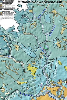
The visible Lauchertgraben is an eleven kilometer long Miocene-Pliocene, Rhenish (i.e. south / north) trending, tectonic rift in the Middle Swabian Alb . The ditch between Veringenstadt and the ruins of Hertenstein (south of Jungnau , where the road to Sigmaringen rises and the Lauchert turns east) is clearly marked morphologically as a deepening. Continuations to the south and north from Veringenstadt to almost Engstingen are no longer morphologically perceptible; however, they are seismically proven and shown in geological maps.
morphology

In GeoMap 7821, Veringenstadt, 1978, one western and two eastern marginal faults are mapped. The western edge fault of the trench is much older than the eastern fault and today only has a flexural shape. On the other hand, the first of the two eastern edge faults , which appear to be like a staggered fracture , is still clearly visible - partly also from heights in the Lauchert valley.
The section from Gammertingen to the north to Engstingen, also known as the “Trochtelfinger Fault ”, is no longer morphologically visible, but only detected seismically .
Geology and dating
From Gammertingen the Lauchert runs in this trench. In Veringenstadt, disturbances in the Lauchertgraben and those in the Hohenzollerngraben from the west are barred . The Lauchert has created a narrow breakthrough in three loops through mighty rock bars.
The two grave systems depend tectonically together, to have hercynian trending fracture faults of Hohenzollern trench in the Rhenish trending Lauchertgraben to Veringenstadt out. So far, however, there is little reliable knowledge about the two trenches and their grilles. The absolute age of the Lauchertgraben and the age relationship between the two trenches is still not certain (as of 2011). More recent publications assume that the Lauchertgraben is somewhat older than the Zollerngraben.
In trenches are a veil heavily weathered scattering gravel an ancient Danube , and even older layers verbackener gravel (Jurassic Nagelfluh ) a Urlauchert been mapped (See "DSPL" and "J2" in the graph of geological map above).

Golwer (1978) formulates the lithostratigraphic and geochronological classification of the eastern marginal faults as follows: "In the Lauchertgraben 1.5 km southwest of Jungnau , the Danube Caves are around 50 m lower than east of the marginal fault on the southwest slope of the Frauenstock". Therefore "[...] already Hennig (1926, p. 73) determined a post-sub-Pliocene age from the different altitudes of the" pliocene "Danube bumps ." Since Golwer adopts this information from 'Hennig 1926, p. 73' without correction, according to the compared to the previously corrected, now generally valid geological time scale standard “Std 2002”, it is assumed that the age is Upper Miocene .
Visual localization
The marginal defects are clearly visible:
- “Langes Tal”, which begins in E Jungnau and runs to N, and its continuation “Zimmerertal”. Especially between the two valleys in the “Brachfeld” area.
- In the outcrop of the Jungnau gravel works, 1 km SE Jungnau;
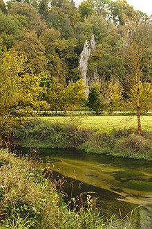
- At the narrow, only approx. 100 m wide, breakthrough point of the southern Lauchert at "Hertenstein", (2.7 km south of Jungnau); recognizable by the mass limestone cliffs "Altes Schloss" / "Hertenstein" and "Raspberry valleys" (both protected geotopes ) , which stand as valley flanks to the south and north .
If you follow the “Langes Tal” to the north from Jungnau or follow the connecting road to the east in Veringendorf for 1.6 km, which leads up to Hochberg , you reach a treeless plain, Gewann “Karge Halde”. From this field, also known as “fallow land”, the untrained eye reveals that the steep, wooded slope opposite is the main disturbance of the trench with a jump height of 100 m.
Where the road pierces the shoulder of the trench and climbs up in a dry valley, the break line on the right is extremely clear through the wooded steep slope and the only slightly sloping open field. The breakline continues from here in the distant fir forest. Only 2.1 km south of the location, in the outcrop of the “Schotterwerk Jungnau, Martin Baur GmbH”, a particularly large number of “pre-Pliocene” upheavals and deportations across the Rhine were measured using geological fault area analyzes (P / T method).

South of Jungnau, at the “Hertenstein”, the southern end of the sunken ditch, the Lauchert leaves the ditch and turns to E. It has the approx. 60 m high eastern fault in a narrow breakthrough valley (between “Raspberry Tales” and “Old Castle” “) Overcome.
Individual evidence
- ↑ pre-eocene , fractional tectonically active until the Miocene , Abel (2003a), p. 52f
- ↑ Erl. GeoK 7621, Trochtelfingen, 1999, p. 52
- ↑ also proven with fault surface population analyzes by Burchardt (2003), p. 46
- ↑ Reinecker & Schneider (2001), "If the Hohenzollerngraben in the Oligocene [would have existed ...], the rivers [Schmiecha-Schmeie and Fehla-Lauchert] would have primarily used this structure.", P. 397; "... the formation of the Hohenzollern trench [...] has a maximum Pliocene age", p. 391
- ↑ "already sedimented at the time of the Swabian volcano" Ufrecht (2006) p. 53
- ↑ Erl. GeoK 7821, Veringenstadt, 1978, p. 86
- ↑ In this text, the geological time scale of the German Stratigraphic Commission (STD 2002) is always used. This standard corrects Pliocene information in older German-language writings for the geology of southwest Germany by 5 million years (!) (Ma) in favor of the Miocene ( stratigraphy ). The adjustment was made at the suggestion of Fahlbusch (1981). Then the 'pliocene' Danube gravel is to be regarded as 'miocene-pliocene' gravel.
- ↑ “Here you are right on the edge of the Lauchertgraben. At this location there were faults and upheavals that mainly point in north-westerly to westerly directions ”, Burchardt (2003), p. 30
- ↑ Burchardt (2003) p. 44
literature
- GeoK BW = "Geological map of BW, State Office for Geology, Raw Materials and Mining, Freiburg, (LGRB) to sheet" No., sheet name, year
- Erl. GeoK = "Explanations for: Geological map from BW, State Office for Geology, Raw Materials and Mining, Freiburg, (LGRB) on sheet" No., sheet name, year
- Hennig (1926): Hennig, E., A young Rhenish disturbance in the Swabian Alb, in: Jh. Ver. fatherly Naturkde. Württ., 82, Stuttgart 1926, pp. 64-76
- Gollwer (1978): see Erl.GeoMap 7821, Veringenstadt, 1978
- Fahlbusch (1981): Fahlbusch, Volker, Miocene and Pliocene - What is what? On the breakdown of the junior tertiary in southern Germany. Mitt. Bayer. Staatsslg. Paleont. hist. Geol. 21, Munich 1981, pp. 121-127
- Reinecker & Schneider (2001): Reinecker, J., Schneider, G., On the neotectonics of the Zollernalb: The Hohezollerngraben and the Albstadt earthquakes, in: Jber. U. Mitt. Oberrh. geol. Ver., Stuttgart 2001, pp. 391-417
- German Stratigraphic Commission, (STD 2002): see web links
- Abel (2003a): Abel, Th., Investigations into the genesis of the Malmkarst of the Middle Swabian Alb in the Quaternary and later Tertiary (Diss. 2003), TGA, C67, Tübingen, 2003
- Burchardt (2003): Burghardt, M., The Neotectonics of the Hohenzollern and Lauchert Graben, Geology, University of Tübingen, Geological Institute, 2003 (Dpl. Thesis)
- Ufrecht (2006): Ufrecht, W., A sealed cave ruin stage on the Kuppenalb between Fehla and Lauchert (Zollernalbkreis, Swabian Alb), Laichinger Höhlenfreund, Laichingen 2006
See also
Web links
- 6. Stratigraphic table of Germany (STD 2002)
- Geotopes in the administrative districts of Baden-Württemberg , (list of protected areas, full texts), LfU, Baden-Württemberg
- Geotope cadastre ( Memento from March 4, 2004 in the Internet Archive ) Baden-Württemberg
Coordinates: 48 ° 8 ′ 12 ″ N , 9 ° 12 ′ 46 ″ E

