
Lute (river)
| Lute | ||
|
|
||
| Data | ||
| location | Upper Harz , Lower Saxony , Germany | |
| River system | Weser | |
| Drain over | Innerste → Leine → Aller → Weser → North Sea | |
| origin | Confluence of two springs at Hahnenklee 51 ° 51 ′ 39 ″ N , 10 ° 19 ′ 19 ″ E |
|
| Source height | approx. 540 m above sea level NN | |
| muzzle | In Lautenthal in the innermost coordinates: 51 ° 52 '11 " N , 10 ° 17' 6" E 51 ° 52 '11 " N , 10 ° 17' 6" E |
|
| Mouth height | 300 m above sea level NN | |
| Height difference | approx. 240 m | |
| Bottom slope | approx. 40 ‰ | |
| length | 6 km | |
| Communities | Langelsheim-Lautenthal | |
The lute is a right tributary of the innermost part of the Upper Harz .
It rises about 540 m west of Hahnenklee . ü. NN at the foot of the Kuttelbacher mountain and flows along the country road 516 to the west. In the densely built-up center of Lautenthal , it flows not far south of Hahnenkleer Straße, the city's oldest street, and is spanned by around a dozen smaller bridges and footbridges. In a side street called “An der Laute” running parallel to the river, the “Smallest House in the West Harz” is a well-known sight in the city. After approx. 6 km it flows into the western edge of Lautenthal west of Wildemanner Straße at an altitude of approx. 300 m. ü. NN in the innermost .
The water of the Lute was always of great importance for Lautenthal, which was founded as a mining town in 1538 - the town developed from a street market that stretched along the Laute along today's Hahnenkleer Straße - because it was used for mining. As early as 1570, the construction of the Lautenthaler Kunstgraben , which still exists today, branches off from the Laute on the eastern edge of the city and supplied several of Lautenthal's mines with water. The water of the lute was z. B. used to transport the ore in barges underground. The ore barge shipping is still a popular attraction in the Lautenthals Glück silver mine, which was converted into a museum in 1982 .
In the years 1669–72 the Harz was hit by a great drought, so that the lute dried out at times and mining had to be stopped for some time.
In 1875 a railway bridge was built over the Laute for the Innerstetalbahn , close to the confluence with the Innerste . Although the railway line was shut down in 1977, the bridge is still well preserved and used by hiking. On April 10, 1877, a flood of the Lute caused considerable property damage in Lautenthal after a dam broke in the area of the New Pond. On July 10 and 11, 1888, after a heavy storm, the lute burst its banks and flooded the street "An der Laute", which was then called "Hinterstraße", so that some people had to be rescued by the fire brigade with ladders.
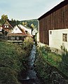
Lute in the east of Lautenthal
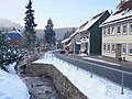
Hahnenkleer Strasse on the Laute

Railway bridge of the former Innerstetalbahn over the Laute at the confluence with the Innerste (in the foreground)


Individual evidence
- ↑ G. Ulrich Großmann: Hannover and Südniedersachsen , p. 187. Cologne 1999
- ↑ Tourist Association Bergstadt Lautenthal e. V .: Lautenthal - where the Harz is at its most beautiful , p. 38. Lautenthal 2003
- ↑ Tourist Association Bergstadt Lautenthal e. V .: Lautenthal - where the Harz Mountains are most beautiful , p. 27. Lautenthal 2003
- ↑ Manfred Kaufeld: From the career and history of the mountain town of Lautenthal , p. 151. Clausthal-Zellerfeld 1988
- ↑ Evert Heusinkveld: The Innerstetal train Langelsheim - Altenau , p 11. Nordhorn 2007
- ↑ Tourist Association Bergstadt Lautenthal e. V .: Lautenthal - where the Harz is at its most beautiful , p. 38. Lautenthal 2003
- ↑ Manfred Kaufeld: From the career and history of the mountain town of Lautenthal , p. 181. Clausthal-Zellerfeld 1988