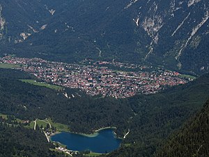
Lautersee
| Lautersee | ||
|---|---|---|

|
||
| Lautersee with Mittenwald | ||
| Geographical location | Upper Bavaria west of Mittenwald | |
| Tributaries | Ditch | |
| Drain | Lainbach → Isar | |
| Places on the shore | Lautersee Alm, Seehof, Lautersee-Stub'n | |
| Location close to the shore | Mittenwald | |
| Data | ||
| Coordinates | 47 ° 26 '19 " N , 11 ° 14' 7" E | |
|
|
||
| Altitude above sea level | 1013 m above sea level NN | |
| surface | 12 ha | |
| length | 470 m | |
| width | 380 m | |
| volume | 1,010,000 m³ | |
| scope | 1.6 km | |
| Maximum depth | 18.6 m | |
| Middle deep | 8.42 m | |

|
||
| Lautersee before Karwendel | ||
The Lautersee is a small mountain lake west of Mittenwald in Upper Bavaria .
location
The approximately 12 hectare large and up to 19 meters deep lake is 1013 m above sea level. NHN south of the Hoher Kranzberg . The lake is fed by small mountain streams, the drain flows as a Lainbach through the Laintal to Mittenwald.
On the shore there is a hotel, a small bathing establishment and rowing and pedal boat rentals, as well as a chapel. The south and east banks can be used as bathing areas. Great crested grebes live by the lake .
The lake can be reached from Mittenwald via the Laintal. A bus line has been running from Mittenwald since the mid-1990s. About 1.5 km west of Lautersee in the direction of Schloss Elmau is Ferchensee .

The lake belonged to the Mittenwald brewery , which harvested ice there to cool beer.
