Lebanon (Kentucky)
|
|
This article was on the basis of substantive defects quality assurance side of the project USA entered. Help bring the quality of this article to an acceptable level and take part in the discussion ! A closer description on the resolving issues is missing. |
| Lebanon | |
|---|---|
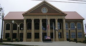
 Marion County Courthouse |
|
| Location in Kentucky | |
| Basic data | |
| State : | United States |
| State : | Kentucky |
| County : | Marion County |
| Coordinates : | 37 ° 34 ′ N , 85 ° 15 ′ W |
| Time zone : | Eastern ( UTC − 5 / −4 ) |
| Residents : | 5,718 (as of: 2000) |
| Population density : | 501.6 inhabitants per km 2 |
| Area : | 11.4 km 2 (approx. 4 mi 2 ) |
| Height : | 241 m |
| Postal code : | 40033 |
| Area code : | +1 270 |
| FIPS : | 21-44344 |
| GNIS ID : | 0496130 |
Lebanon is the county seat of Marion County , in the US state of Kentucky . In 2000 , the place had 5718 inhabitants and a population density of 500.6 inhabitants / km².
geography
The place is near the geographic center of Kentucky on Highway 68, about 90 km southeast of Louisville and 90 km southwest of Frankfort , the capital of Kentucky. The urban area has an area of 11.4 km² without any significant water surface.
history
Lebanon was set as the district capital on January 25, 1834 when Marion County was formed. The area around the city was the site of three battles during the American Civil War in 1861, 1862, and 1863.
sons and daughters of the town
- Phil Simms (* 1954), former American football player
- John Lancaster Spalding (1840–1916), Roman Catholic clergyman and Bishop of Peoria
- Mark Spalding (* 1965), Roman Catholic clergyman and Bishop of Nashville
Web links
Commons : Lebanon, Kentucky - Collection of pictures, videos, and audio files
