Frankfort (Kentucky)
| Frankfort | ||
|---|---|---|
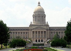
 The Kentucky State Capitol in Frankfort |
||
| Location in Kentucky | ||
|
|
||
| Basic data | ||
| Foundation : | 1786 | |
| State : | United States | |
| State : | Kentucky | |
| County : | Franklin County | |
| Coordinates : | 38 ° 12 ′ N , 84 ° 52 ′ W | |
| Time zone : | Eastern ( UTC − 5 / −4 ) | |
| Residents : | 25,527 (as of 2010) | |
| Population density : | 668.2 inhabitants per km 2 | |
| Area : | 38.9 km 2 (approx. 15 mi 2 ) of which 38.2 km 2 (approx. 15 mi 2 ) is land |
|
| Height : | 155 m | |
| Postcodes : | 40601-40622 | |
| Area code : | +1 502 | |
| FIPS : | 21-28900 | |
| GNIS ID : | 0517517 | |
| Website : | frankfort.ky.gov | |
| Mayor : | Gippy Graham (D) | |
 |
||
Frankfort (also The Big Bend ) is the capital of the state of Kentucky in the United States .
With only approx. 25,500 inhabitants within the actual urban area, the middle town is only 14th of the largest cities in Kentucky and thus significantly smaller than the metropolises of Kentucky, Louisville and Lexington . However, the city is relatively central in the city triangle between the two cities mentioned and Cincinnati , Ohio in the northeast of the state, so that their airports can be reached within 30 to 95 minutes. The Kentucky River flows through the city, dividing it into four urban areas.
history
The city was founded by General James Wilkinson , who purchased 260 acres of land north of the Kentucky River in 1786 . This area is now Downtown Frankfort. The name of the city probably comes from the pioneer Stephan Frank, who was killed by Indians at a ford on the Kentucky River in 1780. In 1792 Frankfort became the capital of the newly formed state of Kentucky.
In the elections for governor in 1899, there were unrest due to the narrow election result. The Republican William S. Taylor indeed received more votes than his Democratic challenger William Goebel , but the General Assembly , the Democrat-dominated Parliament Kentucky, made in a commission of inquiry many votes for Taylor invalid. Goebel was declared the new election winner. There was unrest between supporters on both sides. On January 30, 1900, William Goebel was shot in Frankfort on the way to his inauguration and died shortly afterwards of his injuries. He was sworn in while he was still sick and was governor of Kentucky for three days until his death.

Two locations in Frankfort have National Historic Landmark status , Liberty Hall and the Old State Capitol . 47 buildings and sites in the city are listed on the National Register of Historic Places (NRHP) (as of November 4, 2018).
education
Kentucky State University is located in Frankfort . The city is divided into two school districts and has three public high schools and one private high school. Home schooling is widespread in Frankfort .
Attractions
Frankfort is home to many attractions and various Bourbon Whiskey - Distilleries (about National Distillers with "Old Taylor").
- Gravesite of Daniel Boones , the model for James Fenimore Cooper's leather sock and "hero" of the Indian Wars in real life (215 East Main Street). He is considered the "father" of the state of Kentucky.
- Buffalo Trace Distillery (just one of many distilleries ).
- Switzer Covered Bridge, Hwy. 1261 Switzer, off Hwy. 460 East. A good example of the wooden bridges covered with a roof from the mid-19th century. This bridge is the last of its kind left in Kentucky.
- Frank Lloyd Wright - Zeigler House, 509 Shelby Street. The famous architect designed this private house for the Reverend Jesse Zeigler in 1910 in the prairie style. It is also the only copy of Wright in Kentucky.
sons and daughters of the town
- William H. Hunter († 1842), politician
- Thomas Carlin (1789–1852), Governor of the State of Illinois
- Thomas F. Marshall (1801–1864), politician
- John Cummins Edwards (1806–1888), governor of the state of Missouri
- John J. Hardin (1810-1847), politician
- Humphrey Marshall (1812–1872), officer and politician
- William Wirt Adams (1819–1888), Brigadier General of the Confederate States of America in the Civil War
- Daniel Weisiger Adams (1821–1872), Brigadier General of the Confederate States of America in the Civil War
- George Graham Vest (1830-1904), politician
- Evan E. Settle (1848–1899), politician
- Albert B. Fall (1861–1944), US Senator and Secretary of the Interior of the United States
- John Glover South (1873-1940), diplomat
- Bob Custer (1898–1974), actor, mainly in b-westerns
- Stuart Robertson (* 1943), special effects artist and VFX supervisor
- Crit Luallen (* 1952), politician
- Logan Woodside (born 1995), American football player
Twin cities
Web links
- Official website of the city of Frankfort (English)
- Well illustrated website of the city (English)
Individual evidence
- ↑ Rennick, Robert M. Geographic names field research conducted over a span of approximately 40 years, and annotated on USGS 1: 24,000 scale topographic maps which date from 1938 to 1973. This data was also used in several published works by the author that were published during and after the field research was conducted
- ↑ List of NHL by State . National Park Service , accessed November 4, 2018.
- ↑ Search mask database in the National Register Information System. National Park Service , accessed November 4, 2018.

