San Pedro de Macorís
| San Pedro de Macorís | ||
|---|---|---|
|
Coordinates: 18 ° 27 ′ N , 69 ° 18 ′ W Location of San Pedro in the Dominican Republic
|
||
| Basic data | ||
| Country | Dominican Republic | |
| province | San Pedro de Macorís | |
| City foundation | 19th century | |
| Residents | 194,000 (2008) | |
| City insignia | ||
| Detailed data | ||
| height | 0 m | |
| Waters | Caribbean | |
| Time zone | UTC −4 | |
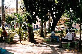
| Park in San Pedro | ||
San Pedro de Macorís is a city in the Dominican Republic with approx. 194,000 inhabitants in the city itself and approx. 23,000 inhabitants in the surrounding area (almost 217,000 in the agglomeration ). San Pedro de Macoris is thus the third largest city in the Dominican Republic. As the provincial capital, it houses the Universidad del Este .
San Pedro de Macoris had its heyday at the beginning of the 20th century , when the sugar was sold on the preferred market in the United States at the then fantastic price of twenty-two centavos . At that time the residents are said to have danced for joy on the street, which went down in the history of the young city as the dance of the millions , because a large number of additional workers had to be recruited for the following economic boom. Most of them are black-skinned English-African immigrants from Tortola , one of the British Virgin Islands . These workers and their descendants are still called cocolos , based on the name of their island of origin, Tortola .
geography
The city is located on the Caribbean's south coast, about 80 km east of the capital Santo Domingo.
Attractions
San Pedro de Macorís is predominantly an industrial city with few tourist attractions. Sights in the area include the fishing village of Bayahibe with its picture- perfect beach and Isla Saona in the Del Este National Park. In San Pedro itself, the buildings on the coastal road, which still bear witness to the city's former wealth, as well as the church of San Pedro Apóstol with its gargoyles and church windows in classical style are worth seeing. The fire station is also worth a detour. San Pedro de Macoris has no international charisma, but supraregional for the Dominican Republic. In 2009 caves discovered nearby in Cumayasa (20 km SE) were opened to visitors. Among other things, old cave paintings should be on view there.
traffic
The destination airport for San Pedro de Macorís is either the smaller airport in the neighboring city of La Romana (LRM, approx. 46 km away) or, in the other direction, the largest Dominican airport, Las Américas (SDQ, approx. 67 km away).
San Pedro de Macorís has had a bridge over the Río Higuamo since 2007, which is the longest bridge in the Caribbean . The total length of the bridge is 620 meters, 390 meters of which is the hanging part. The bridge is 24.80 meters wide. It should be hurricane-proof and withstand wind speeds of up to 240 km / h. The bridge is part of the motorway connection to La Romana and continues to the tourist centers of Punta Cana and Bávaro. The official name of the bridge is Puente Mauricio Baez .
sons and daughters of the town
- Bienvenido Bustamante López (1923–2001), composer and clarinetist
- Niní Cáffaro (* 1939), singer
- José Manuel Calderón (* 1941), bachata singer, composer and guitarist
- Robinson Canó (* 1982), major league baseball player
- Bienvenido Fabián (1920–2000), composer, pianist and singer
- Ivonne Haza (* 1938), soprano
- Mario de Jesús Báez (1924–2008), composer and music publisher
- René del Risco Bermúdez (1937–1972), writer
- Sammy Sosa (* 1968), major league baseball player
- Sonia Silvestre (1952-2014), singer
- Violeta Stephen (born 1929), singer
- Dioris Valladares (1916–2001), composer, arranger, singer, band leader, guitarist and percussionist
- Julio de Windt (* 1935), conductor, violinist and music teacher
- Jorge Polanco (* 1993), major league baseball player
Honorary citizen
- Carl-Theodor Georg (1884–1966), German doctor
Individual evidence
- ↑ Iguamo River (Eng. WP)


