
Leopoldsreut


Leopoldsreut or "Sandhäuser" is a village located at 1110 m and has been abandoned since 1963 in the municipality of Haidmühle in the Lower Bavarian district of Freyung-Grafenau . Until 1875 the spelling was Leopoldsreuth .
history
The then sovereign of the bishopric of Passau , Prince-Bishop Leopold V , arranged to create a forest village with nine properties to secure the border in 1618 at the height of the Haidel and to name it after him; the ending “-reut” means “clearing”.
After the village was a toll station on the Goldener Steig in the 17th century , it increasingly lost this importance. At times, was used for the glass industry and quartz sand mined. Hence the popular name "sand houses" for Leopoldsreut.
In the 18th century, the inhabitants increasingly lived from agriculture and cattle breeding. The pasture areas were enlarged considerably.
From 1818 the work situation improved as the residents found work in the forests around Bischofsreut , which resulted in a decline in agricultural activity. Because of the arduous life - a popular saying went: "In Sandhaiser it has three quarters of Joar winter and a quarter of Joar is koid", because in winter the place was sometimes cut off for weeks or months from Bischofsreut, five kilometers away - the first families moved from the village around 1859 path. This was the beginning of the slow death of the place, which in 1889 still had 152 inhabitants. From now on, owners and tenants of the property changed in quick succession. On April 27, 1951, the name of the municipality Leopoldsreut was officially changed to Bischofsreut . The school was closed in 1955 and the remaining five children had to travel five kilometers to school to Bischofsreut. The absence of the effects of the economic miracle after the Second World War - until recently there was no electricity, no pressurized water pipeline, poor infrastructure - led to the departure of the last residents in 1963 and the demolition of the buildings that were still in existence.
Today only the newly renovated church , the former school, which used to be the highest school in Germany, and the former forester's house.
The cross in the renovated Leopoldsreuter Church was carved by Fritz Schuster (1922–1987), the “Lord God Carver of Grainet”, from oak beams of the abandoned houses.
useful information
In 2007 Peter Reichardt from Hinterschmiding made a documentary film for his grandmother from Leopoldsreut . This was performed in front of an audience on September 5, 2008 at the original location in front of the chapel in Leopoldsreut.
The school building at 1108 m was considered the highest school in Germany until the school was closed in 1955.
Personalities
- Walter Landshuter (born July 29, 1945 in Leopoldsreut), co-initiator and owner of the Executioner's House in Passau
Old village views

Postcard from 1906 in summer
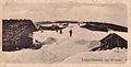
Postcard from 1906 in winter

Postcard from 1906 inn

Postcard from 1935 Gasthaus zur lofty heights


literature
- Peter Hofer: Leopoldsreut. The disappeared village. Edition Lichtland 2014, ISBN 978-3942509350 .
- Heinrich Lippert: The Leopoldsreut School. On the history of what was once Germany's highest elementary school in the Bavarian Forest. (1826-1956). Ohetaler Verlag, Riedlhütte 2007, ISBN 978-3-937067-74-2 .
- Peter Reichardt: Leopoldsreut - The story of a lost village in the Bavarian Forest ; Documentary. Publisher: Morsak 2007; ISBN 978-3-86512-036-6
Web links
- The missing village Süddeutsche Zeitung from February 13, 2013, accessed January 11, 2018
- Doris Löw: DVD: Leopoldsreut. The father always woit hoam ; Article in the Passauer Neue Presse from January 19, 2008, p. 3
Individual evidence
- ↑ Bavarian State Statistical Office (Hrsg.): Historical municipality register: The population of the municipalities of Bavaria in the period from 1840 to 1952 (= contributions to Statistics Bavaria . Issue 192). Munich 1954, DNB 451478568 , p. 74–75 , urn : nbn: de: bvb: 12-bsb00066439-3 ( digitized version - Wolfstein district, footnote 6).
- ^ Wilhelm Volkert (ed.): Handbook of Bavarian offices, communities and courts 1799–1980 . CH Beck, Munich 1983, ISBN 3-406-09669-7 , p. 595 .
Coordinates: 48 ° 50 ' N , 13 ° 41' E