Letka
|
Letka Летка |
||
|
|
||
| Data | ||
| Water code | RU : 10010300212111100031600 | |
| location | Komi Republic , Kirov Oblast ( Russia ) | |
| River system | Volga | |
| Drain over | Vyatka → Kama → Volga → Caspian Sea | |
| source |
Northern Russian ridge 59 ° 51 ′ 51 ″ N , 50 ° 0 ′ 31 ″ E |
|
| muzzle | in the Vyatka coordinates: 58 ° 58 ′ 0 ″ N , 50 ° 12 ′ 25 ″ E 58 ° 58 ′ 0 ″ N , 50 ° 12 ′ 25 ″ E
|
|
| length | 260 km | |
| Catchment area | 3680 km² | |
| Discharge at the Kazan gauge Location: 45 km above the mouth |
MQ |
20.6 m³ / s |
|
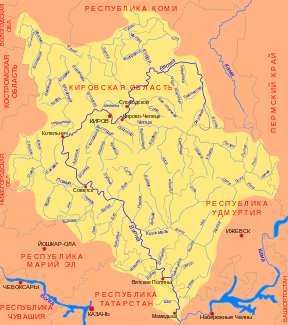
Location of the Letka (Летка) in the catchment area of the Vyatka |
||
The Letka ( Russian Летка ) is a right tributary of the Vyatka in the Komi Republic and Kirov Oblast in the European part of Russia .
The Letka rises on the northern Russian ridge . It flows west first and later turns south. It finally joins the Vyatka from the right east of the town of Slobodskoi . The Letka has a length of 260 km. It drains an area of 3680 km². 45 km above the mouth, the mean discharge (MQ) is 20.6 m³ / s.
Individual evidence
- ↑ a b c Article Letka in the Great Soviet Encyclopedia (BSE) , 3rd edition 1969–1978 (Russian)
- ↑ a b Letka in the State Water Register of the Russian Federation (Russian)
