Lexington, Mississippi
| Lexington | |
|---|---|
|
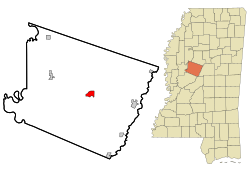
Location in Mississippi
|
|
| Basic data | |
| State : | United States |
| State : | Mississippi |
| County : | Holmes County |
| Coordinates : | 33 ° 7 ′ N , 90 ° 3 ′ W |
| Time zone : | Central ( UTC − 6 / −5 ) |
| Residents : | 2,025 (as of: 2000) |
| Population density : | 316.4 inhabitants per km 2 |
| Area : | 6.4 km 2 (approx. 2 mi 2 ) of which 6.4 km 2 (approx. 2 mi 2 ) is land |
| Height : | 71 m |
| Postal code : | 39095 |
| Area code : | +1 662 |
| FIPS : | 28-40600 |
| GNIS ID : | 0672434 |
| Website : | www.lexingtonms.com |
Lexington is a small town in Holmes County in the US state of Mississippi with 2,025 inhabitants (2000 census). The geographic coordinates are: 33 ° 6'52 "north, 90 ° 3'4" west. The city area is 6.4 km². The city's ZIP code is 39095. The city is the county seat of Holmes County and is approximately 90 km north of the federal capital Jackson .
The city was founded in 1833 and named after the city of Lexington , Massachusetts , where the American Revolutionary War began. In Lexington, Mississippi, roughly two-thirds of the population are of black African descent.
sons and daughters of the town
- Buford Ellington (1907–1972), politician and 47th and 49th Governors of Tennessee
- Malachi Favors (1937-2004), jazz bassist
- Smokey Smothers (1929–1993), blues guitarist and singer
