
Chamonna Linard
| Chamonna Linard SAC hut |
||
|---|---|---|
 Chamonna Linard and Piz Linard from the southeast |
||
| location | Southeast of Piz Linard; Canton of Graubünden / Switzerland ; Starting point: Lavin | |
| Mountain range | Silvretta | |
| Geographical location: | 801 906 / 184319 | |
| Altitude | 2327 m above sea level M. | |
|
||
| owner | SAC - Engiadina Bassa section | |
| Built | 1902 | |
| Construction type | hut | |
| Usual opening times | July to mid-October | |
| accommodation | 0 beds, 38 camps , 20 emergency camps | |
| Web link | Site of the hut | |
| Hut directory | SAC | |

The Chamonna Linard ( Rhaeto-Romanic in the idiom Vallader for Linardhütte ) is a mountain hut belonging to the Swiss Alpine Club (SAC), Engiadina Bassa section, in the canton of Graubünden in Switzerland .
The hut has 46 beds. The hut is open from the beginning of July to mid-October, but only on weekends from mid-September. Outside of this time, the hut can be used as a self-catering hut. During the maintenance period, the hut is looked after by members of the section on a voluntary basis on a weekly basis.
location
The hut is located at an altitude of 2327 m above sea level. M. northwest above Lavin in the Lower Engadine Inn valley . It is located just under 2½ km southeast of Piz Linard in Val Glims, framed by its ridge . The hut is located about 30 m east of the brook coming down from the valley basin, between this and an old green moraine ridge (southern continuation of the Sassau valley), above a waterfall.
history
In 1902 the first hut was built on this site, the construction costs at that time were 5700 francs. Renovations were carried out in 1915, 1967, 1977 and most recently in 1995, maintaining the traditional style of the SAC. Electricity can be generated with a small hydroelectric power station or alternatively with a gasoline generator. The supply is done by helicopter, smaller things, such as. B. fresh produce, are also carried up by the volunteers.
Approach
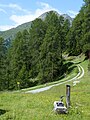
The almost exclusively used hut access starts in Lavin. The well-marked and signposted path leads over a bridge over the Lavinuozbach and initially crosses the south-facing slopes above the Inn Valley in a westward direction. The trail that leads through larch forest and shortens the road later turns east and reaches the Plan dal Bügl pasture ( 1958 m ), where there is a small hut and an alpine cross. There the now somewhat steeper path turns north-west and reaches the Val Glims , where the hut can be seen for the first time. Now the path leads over a couple of rocks with chains and grassy slopes to the hut. It takes about 2½ hours from Lavin. This boarding can also be reached from Sagliains train station without any significant time difference .
Tour possibilities
By far the summit most approached by the hut is Piz Linard ( 3410 m ), which is usually reached from the hut on one of the following routes:
- via the south face rib (4 hours, normal route, winter semester , climbing sections up to II )
- over the southeast ridge (4 hours, ZS- , climbing sections II-III )
Other possible summit destinations from the hut are:
- Piz Glims ( 2868 m , 2–3 hours)
- Piz Sagliains ( 3101 m , 4–5 hours)
- Piz Zadrell ( 3,104 m , 5–6 hours)
- Record horns (up to 3220 m , 5–6 hours)
- Sassautagrat (several unnamed peaks south of Piz Linard Pitschen (2973 m))
In addition , numerous hikes are possible from the hut, especially over the Fuorcla da Glims ( 2808 m ), over which a marked hiking trail leads. Halfway to the pass, the path leads past the two lakes Lai Glims (altitude of the lower lake according to the signpost there 2563 m) and continues past the foot of Piz Linard. You also pass both lakes if you approach Piz Linard from the south.
Plan da Bügl (1962 m) on the ascent to the hut

Ascent with a view of the hut, Piz Linard and Piz Glims (left)

Hut with Piz Linard

Guest room

Lai Glims with Piz Linard above the hut

View from Chammona Linard to the south


Web links
- Site of the hut
- Circular hike over the Linardhütte at wegwandern.ch
Individual evidence
- ↑ a b c d e f Homepage of the hut
- ↑ CAS Engiadina Bassa: Cudeschin Nr.55 ( page no longer available , search in web archives ) Info: The link was automatically marked as defective. Please check the link according to the instructions and then remove this notice. . April 2017
- ^ Günther Flaig, Walther Flaig: Silvretta alpin . Bergverlag Rother, Munich 1996, ISBN 3-7633-1097-5 , pp. 103ff
- ↑ Engadiner Post , No. 58, May 18, 2017
- ^ Richard Goedeke: 3000 m in the northern Alps. Bruckmann, Munich 2004, ISBN 3-7654-3930-4 , p. 72f