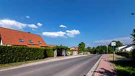
Linda (Mechelroda)
|
Linda
Mechelroda municipality
Coordinates: 50 ° 54 ′ 42 ″ N , 11 ° 24 ′ 3 ″ E
|
|
|---|---|
| Height : | 350 m above sea level NN |
| Incorporation : | 1850 |
| Postal code : | 99441 |
| Area code : | 036453 |
|
Location
|
|
Linda is a district of Mechelroda in the Weimarer Land district in Thuringia .
geography
Linda is located south of the federal motorway 4 on a somewhat barren plateau of the Saale-Ilm limestone plateau, sloping to the north, about 350 meters above sea level. The traffic connection to the distance is given with the nearby junction of the federal motorway at Magdala .
history
Linda is first mentioned in a document in 1338. At this mention, the noble family Linde was also mentioned. This is where the name of the place comes from. In 1450 the settlement was abandoned. In the 16th century, the Blankenhain rulers established a sheep farm. Linda has been incorporated into Mechelroda since 1850. The farmers in both places had to do long labor . In 1815 the 191 hectare estate was named Kammergut . In 1906 the estate was sold to farmers and nationalized during the GDR era .
Web links
Individual evidence
- ^ Wolfgang Kahl : First mention of Thuringian towns and villages. A manual. 5th, improved and considerably enlarged edition. Rockstuhl, Bad Langensalza 2010, ISBN 978-3-86777-202-0 , p. 166.
- ↑ Linda on the community of Mechelroda. ( Memento of the original from August 13, 2011 in the Internet Archive ) Info: The archive link was inserted automatically and has not yet been checked. Please check the original and archive link according to the instructions and then remove this notice. Retrieved January 7, 2012.
