List of soil monuments in Malschwitz
In the list of soil monuments in Malschwitz , the soil monuments of the municipality of Malschwitz and its districts are listed according to the status of the list by Harald Quietzsch and Heinz Jacob from 1982. Any changes and additions, especially from the time after the fall of the Wall , are not taken into account, as there are currently no newer, generally accessible soil monument lists for Saxony . The architectural monuments are listed in the list of cultural monuments in Malschwitz .
| Monument ID | Find type | District | designation | Time position | location | Remarks | image |
|---|---|---|---|---|---|---|---|
| ? | Fortification> castle | Baruth | Moated castle | middle Ages | southwest outskirts, area of the demolished castle | Superficially leveled, partially built over, protection since November 10, 1970 | |
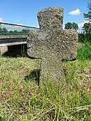
| ? | special stone | Baruth | Stone cross | Late Middle Ages | northeastern district, east of the church, south of the road to Dubrauke | Sword marking, protection since August 25, 1971 | |
| ? | Fortification> castle | Doberschütz | Moated castle | middle Ages | western outskirts, east of the Andreasteich, in the floodplain of the Kleine Spree | Overbuilt by mill buildings, trench partially filled, protection since June 22, 1935, renewed December 1, 1958 |

|
| ? | special stone | Gleina | Stone cross | Late Middle Ages | north-northwest of the place on the west bank of the Kotitzer water | Protection since June 30, 1971 |

|
| ? | Fortification> castle | Gleina | Moated castle | middle Ages | southeast outskirts, south of the estate, north of the road | Overbuilt, no longer visible on the surface, protection since October 8, 1935, renewed December 1, 1958 | |
| ? | Fortification> castle | Guttau | "Schlösschen" moated castle | middle Ages | southern district, west side of the estate | Built over, Bühl embankment recognizable, ditch leveled, protection since May 4, 1936, renewed December 1, 1958 | |
| ? | special stone | Guttau | Stone cross | Late Middle Ages | south on the road to Kleinsaubernitz , east of the junction to Neudörfel | Protection since July 20, 1971 |

|
| ? | Tomb> burial mound | Halbendorf / Spree | suspected barrows | Bronze age | directly north of the village, west of the Spree in the forest | 4 hills, no stone settlements recognizable, protection since May 20, 1971 | |
| ? | special stone | Halbendorf / Spree | Stone cross | Late Middle Ages | southwest outskirts, west of the road to Spreewiese | Sword marking, protection since June 23, 1971 | |
| ? | Fortification> castle | Small buildings | Moated castle | middle Ages | southeast outskirts, southern estate area, in the floodplain of the Albrechtsbach | Built over, Bühl embankments recognizable, ditch leveled, protection since December 10, 1970 | |
| ? | Fortification> castle | Kleinsaubernitz | Wall system "Radisch" | Early Iron Age , Middle Ages | northwest of the place on an island in the Olbasee | Almost completely destroyed by mining, only remains preserved, protection since July 21, 1937, renewed December 1, 1958 | |
| ? | Fortification> castle | Malschwitz | "Old Castle" moated castle | middle Ages | southwest outskirts, western estate area | Overbuilt by a manor house, drained parts of the trench preserved, protection since February 16, 1937, renewed December 1, 1958 | |
| ? | Fortification> castle | Low | Wall system "Lubasschanze" | Slav period | south of the village, eastern high bank of the Spree | Ring wall on the edge of the lowlands, protection since February 16, 1937, renewed February 1, 1959 | |
| ? | special stone | Low | Stone cross | Post Middle Ages | south-south-west of the place, west on the way to Gottlobsberg | Inscription from 1800, protection since July 20, 1971 |

|
| ? | special stone | Low | Cup stone | undated | south-southwest of the place on the summit of the Gottlobsberg | Granite block with approx. 20 bowls and 2 basins, protection since May 20, 1971 | |
| ? | special stone | Pliesskowitz | Cup stone " Devil's Stone " | undated | southeast of the place, northeast of the quarry | Rock group with kettle-shaped bowls and incised drawings, protection since February 6, 1936, May 20, 1971 |

|
| ? | Fortification> castle | Rackel | Wall system "Schanze" | Slav period | southwest of the place, eastern high bank of the Löbauer water | Spur fortifications with almost closed ramparts, protection since January 17, 1935, renewed February 1, 1959 | |
| ? | special stone | Rackel | Stone cross | Late Middle Ages | directly east of the village, south on the road | Protection since August 25, 1971 |
literature
- Harald Quietzsch , Heinz Jacob : The protected ground monuments in the Dresden district (= small writings of the State Museum for Prehistory Dresden. Volume 2). State Museum for Prehistory, Dresden 1982, pp. 8, 11–15, 17–19.