
Olbasee
| Olbasee | ||
|---|---|---|

|
||
| Geographical location | Kleinsaubernitz and Wartha, Malschwitz municipality , Bautzen district , Saxony , Germany | |
| Tributaries | Small drainage ditches | |
| Drain | Stand structure to the Alter Fliess | |
| Islands | The Radisch | |
| Data | ||
| Coordinates | 51 ° 16 '18 " N , 14 ° 35' 31" E | |
|
||
| Altitude above sea level | 141.5 m above sea level NN | |
| surface | 50 ha | |
| length | 1.2 km | |
| width | 700 m | |
| Maximum depth | approx. 35 m | |

The Olbasee is a former lignite opencast mine and today a swimming lake in the Upper Lusatian heath and pond landscape between the places Wartha and Kleinsaubernitz in the municipality of Malschwitz , Saxony.
The name is derived from the O about l ausitzer B raunkohlen- A ktiengesellschaft from the operating surface mining.
geology
The Kleinsaubernitz lignite deposits and thus the lake in the "Kleinsaubernitz basin" are located in the center of a maar structure of the Oligocene Age. The basement consists of granodiorites from the Lusatian massif . This is overlaid in the north by silica-slate-chert conglomerate. On the surface there are relics of late Tertiary deposits and the Pleistocene. The eruption crater, which is now completely covered and not visible in the terrain, has a diameter of 800 meters and a depth of over 1000 meters.
history
The lignite was probably discovered after 1850 while sinking a well west of the road to Niesky . According to another tradition, the later mine operator Große encountered “black earth” while creating drainage ditches.
The Pötschke and Große lignite mines are known from 1853. From the beginning to the end of mining, both underground and open-cast mining took place. The "Graf zur Lippe" colliery was operated from 1865 by the manor owner of the same name from Baruth . Their facilities and buildings were located northeast of today's sports field west of the town of Kleinsaubernitz. At first, mining was limited to the area of today's swamp and dump area between today's settlement on Nieskyer Strasse and the lake.
Lignite mining experienced a general upheaval at the beginning of the 20th century. With the decision to build a briquette factory and a rail connection, a significant expansion of the dismantling was necessary. For this purpose, a new opencast mine was opened north of the old pits, ie in the direction of the old Warthaer Strasse. Mining later shifted to the south. Contrary to the expected mighty seams, however, geological faults and faults were repeatedly encountered, causing production to stall. Kieselguhr flowing out of the hanging wall caused additional problems, some of which was also dismantled in the secondary operation.
New wells gave hope for additional, but deeper reserves. The Radisch field was opened up north of today's island. In addition to the direct mining of lignite in the opencast mine, additional shafts were sunk south of the "Radisch" from the opencast mine bottom, up to approx. 70 m below the surface. To the north of the island, mining continued in the opencast mine, which extended to Warthaer Strasse and the farms there (today a camping site).
Initially, a cable car was used to transport it to the briquette factory. A little later this was replaced by a chain lift. This crossed under Nieskyer Strasse directly next to the country store (now a bistro).
In addition to the difficult storage conditions here, the instabilities caused by kieselguhr and the stagnant water, the labor shortage during and after the First World War troubled the mine. At that time, the owner was the entrepreneur Ignaz Petschek . The manifold problems suggest that the mining could hardly have been economical. The end of lignite mining came on October 3, 1927, when a fire alarm was suddenly given while the morning shift was being read. Three miners lost their lives in the fire. The cause of the fire was suspected from the start. However, the suspicion was not investigated further.
After the decision to cease operations, usable equipment was removed and the pits were flooded. By the spring of 1932 the water level reached its present level. Leveling and recultivation work was carried out in the 1930s.
Of the approx. 75 years of mining history, essentially only the lake remains today. Less prominent and hardly recognizable under the dense vegetation are the filled pits and heaps in the area of Nieskyer and Warthaer Straße. Entering the dump and swamp area still represents a risk and a risk to life and limb. Entering the old mine workings is life-threatening.
tourism
From the 1950s, the tourist use developed. The first weekend houses were built on the shores of the lake. At first these were only tolerated by the council of the community of Kleinsaubernitz. From the 1960s the area was officially opened up as a local recreation area. At this time, the beach on the north bank was created.
There are two campsites and several cottage settlements. There is a diving club on the lake, which operates a diving base on the lake, and several water sports clubs . Restaurants and shops are available.
The water is acidic, but is usually suitable for bathing. It has a visibility depth of around two meters, a high level of oxygen saturation and has above-average levels of iron and sulfate. The water chemistry changes depending on whether fresh water comes from the old river or only acidic water from the old mining dumps. The flora and fauna under water depend on the respective water chemistry. In spring, when fresh water dominates the surface after the snowmelt and the spring floods, lively life develops. In autumn and winter, on the other hand, the biology "overturns" due to the penetration of acid mine water . The lake is not a fishing water, but pike have been caught, mostly dwarf catfish.
There is a path around the lake that can be hiked. The area is directly integrated into the educational concept of the biosphere reserve and its marked routes. The path between Kleinsaubernitz and Wartha is paved, closed to through traffic and therefore suitable for skaters.
The Radisch
In the middle of the lake there is a ten hectare island, the " Radisch ", an old castle rampart, the remnants of which are barely visible on the eastern half of the current island. The island may not be entered due to mining-related subsidence risks.
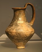
M. Wilhelm presented the prehistory in detail as part of the special exhibition "From Radisch to Olba - History of a Landscape" in 1999 in the Bautzen City Museum. The name "Radisch" is derived from the Sorbian hrodźiško (fortified place, hill, fortification). In fact, there was an old castle hill east of today's island until the beginning of the 20th century. Excavations from this time, ie before large parts of the mine were excavated, brought medieval finds from the 13th / 14th centuries. Century to days. In addition to ceramics made on pottery wheels, a fragment of a horseshoe, pliers and parts of equestrian equipment. The findings were interpreted as a medieval "tower hill". Its size of 38 × 27 meters is unusual. In comparison with a hill excavated in Crostau and only 18 × 11 meters in size, one can assume that farm buildings belonging to the manorial court also stood here. The obvious interpretation is that of the sovereign border fortification of the German colonization in the east. The name of the neighboring village Wartha (guard station, Wegwarte) would also speak for this.
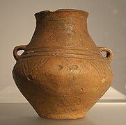
Even older archaeological finds were assigned to the Bronze and Early Iron Ages. The oldest finds of sherds date from 1000 to 750 BC. The main period of use is 750 - 500 BC. Chr. Indicated. From this time remains of a rampart destroyed by fire, post holes of houses, hearths and grave goods are documented. The ramparts enclosed an area of 1.8 hectares (Billendorfer group; see M. Wilhelm).
- Finds from the Iron Age from Radisch, State Museum for Archeology Chemnitz


Today's island is not identical in shape to the pre-mining grove of Radisch. About a third was lost to mining in the northeast. In the west, however, dump materials were heaped up. These are easy to see on the side facing the Wartha campsite. The heaps are very rich in carbon and sulfur, so that there is hardly any vegetation. The two smaller islands also owe their origin to mining.
literature
- Upper Lusatian heather and pond landscape (= values of the German homeland . Volume 67). 1st edition. Böhlau, Cologne / Weimar / Vienna 2005, ISBN 978-3-412-08903-0 , p. 299ff.
- Wolf, J. (1995): Inventory, mapping and evaluation of the old mining area around the open pit Olbasee, Kleinsaubernitz, district of Bautzen. Diploma thesis, TU Bergakademie Freiberg. - Freiberg. Tkr.
- Wilhelm, M. (1999): From Radisch to Olba - History of a Landscape, City Museum Bautzen, booklet for the special exhibition of the same name
Individual evidence
- ↑ Archived copy ( Memento of the original from June 3, 2012 in the Internet Archive ) Info: The archive link was inserted automatically and has not yet been checked. Please check the original and archive link according to the instructions and then remove this notice.