
Lobata (Sao Tome and Principe)
| Lobata | |
|---|---|
  |
|
| Basic data | |
| Country | Sao Tome and Principe |
| Capital | Guadalupe |
| surface | 105 km² |
| Residents | 19,365 (2012) |
| density | 184 inhabitants per km² |
| ISO 3166-2 | ST-S |
Coordinates: 0 ° 22 ′ N , 6 ° 39 ′ E
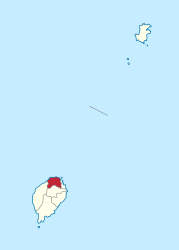
Lobata is one of seven districts of São Tomé and Príncipe and is located on the island of São Tomé . It is the third largest district in terms of population. It covers an area of 105 km². The capital is Guadalupe . The district also includes the island of Ilhéu das Cabras .
Population development
- 1940 9,240 inhabitants (15.2% of the total population)
- 1950 8,190 inhabitants (13.6% of the total population)
- 1960 7,875 inhabitants (12.3% of the total population)
- 1970 9,361 inhabitants (12.7% of the total population)
- 1981 11,776 inhabitants (12.2% of the total population)
- 1991 14,173 inhabitants (12.1% of the total population)
- 2001 15,187 inhabitants (11.0% of the total population)
- 2012 19,365 inhabitants (10.8% of the total population)
Individual evidence
- ↑ Instituto Nacional de Estatística: Projecção a nível distrital 2012 - 2020. (pdf) March 8, 2018, accessed on September 7, 2019 (Portuguese, French).