Loosahatchie River
| Loosahatchie River | ||
|
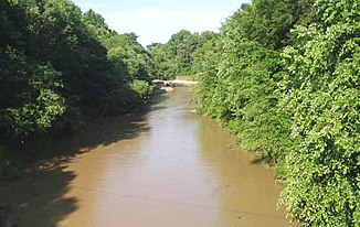
The Loosahatchie River near Arlington , Tennessee |
||
| Data | ||
| Water code | US : 1269767 | |
| location | Tennessee , United States | |
| River system | Mississippi River | |
| Drain over | Mississippi River → Gulf of Mexico | |
| source | in Hardeman County 35 ° 12 ′ 14 " N , 89 ° 10 ′ 36" W. |
|
| muzzle | in Shelby County in the Mississippi River Coordinates: 35 ° 12 ′ 44 " N , 90 ° 3 ′ 38" W 35 ° 12 ′ 44 " N , 90 ° 3 ′ 38" W
|
|
| length | 103 km | |
| Discharge at Arlington (Tennessee) A Eo gauge : 678 km² |
NNQ (1974) MQ 1970–2011 Mq 1970–2011 HHQ (2010) |
1.9 m³ / s 11.2 m³ / s 16.5 l / (s km²) 840 m³ / s |
The Loosahatchie River is a 103 km long tributary of the Mississippi in southwest Tennessee . With the exception of a few kilometers near the mouth, in its headwaters and in the middle reaches, the river and its tributaries have been severely straightened in order to serve the irrigation of agriculture . Its catchment area was once the center of extensive plantations of cotton by the strong urbanization have been displaced in recent decades. The name of the river is partially redundant because hatchie in several languages of the Indians of the Southeast River means.
course
The Loosahatchie River rises in the west of Hardeman County and flows roughly east-west to its confluence. The river reaches Fayette County , flows through Somerville and is crossed by Interstate 40 west of the city in the only uneven section of its central reaches before reaching Shelby County . Its mouth is just north of Frayser, a suburb of Memphis , where on Mud Island north of the mouth of the Wolf River joins the Mississippi River. Shortly below this mouth, in the main arm of the river, is the shoal Loosahatchie Bar, named after the Loosahatchie River.
Hydrology
The United States Geological Survey has operated a gauge near Arlington since 1969 (reference number: 07030240, geographic coordinates : 35 ° 18 ′ 39.1 ″ N , 89 ° 38 ′ 22.1 ″ W ). The catchment area above this point covers an area of 678 km². The long-term average runoff between 1970 and 2011 is 11.2 m³ / s. The highest runoff rate since then was recorded here on May 2, 2010 with 840 m³ / s. The lowest flow rate with about 1.9 m³ on April 6, 1974.
See also
Web links
- Loosahatchie Watershed Water Quality Management Plan . State of Tennessee Department of Environment and Conservation (English).
- Arlington, TN gauge data and information . USGS website.
- Loosahatchie River @ Arlington . Water level forecast from NOAA's Advanced Hydrological Prediction Service.
supporting documents
- ↑ a b 07030240 LOOSAHATCHIE RIVER NEAR ARLINGTON ( English , PDF; 104 kB) In: Water-Data Report 2011 . United States Geological Survey . P. 3. Retrieved July 17, 2012.
