Los Alamos (New Mexico)
| Los Alamos | |
|---|---|
 Ashley Pond, downtown Los Alamos |
|
| Location in the county | |
| Basic data | |
| State : | United States |
| State : | New Mexico |
| County : | Los Alamos County |
| Coordinates : | 35 ° 53 ′ N , 106 ° 18 ′ W |
| Time zone : | Mountain ( UTC − 7 / −6 ) |
| Residents : | 12,019 (as of 2010) |
| Population density : | 427.7 inhabitants per km 2 |
| Area : | 28.1 km 2 (about 11 mi 2 ) of which 28.1 km 2 (about 11 mi 2 ) are land |
| Height : | 2231 m |
| Postcodes : | 87544-87545 |
| Area code : | +1 505 |
| FIPS : | 35-42320 |
| GNIS ID : | 0901357 |
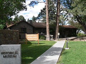
 Historical Museum in Los Alamos |
|
Los Alamos ( Spanish for poplars ) is a town in Los Alamos County , New Mexico with a population of 12,019. In the place is the Los Alamos National Laboratory , in which the Manhattan Project was carried out. Los Alamos is at the center of the color series of the same name by photographer William Eggleston, completed in 1976 .
geography
The extension of the place is 28.1 km².
Demographics
At the 2000 census, the place had 11,909 inhabitants and 5,110 households. The population density is 423.8 inhabitants / km².
Of the 5,110 households, 31.4% have children under the age of 18, 56.4% are married couples, 6.5% are single women and 34% are not families. 29.8% are single households and in 7.6% of the cases it is a person over 65 years of age. The average household size is 2.31 and the average family size is 2.89.
sons and daughters of the town
- Carol Cady (born 1962), track and field athlete
- Michael Creutz (* 1944), theoretical physicist
- Drew Goddard (* 1975), screenwriter
