Lossite (Kilmeny)
| Lossite | ||
|---|---|---|
| Lossit Farm | ||
| Coordinates | 55 ° 49 ′ N , 6 ° 8 ′ W | |
|
|
||
| administration | ||
| Post town | ISLE OF ISLAY | |
| ZIP code section | PA46 | |
| prefix | 01496 | |
| Part of the country | Scotland | |
| Council area | Argyll and Bute | |
| British Parliament | Argyll and Bute | |
| Scottish Parliament | Argyll and Bute | |
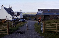
Lossit is a hamlet near the east coast of the Scottish Hebridean island of Islay . The village is four kilometers southwest of the Port Askaig ferry terminal and twelve kilometers northeast of Bowmore , the main town on the island. Lossit is on the northeast bank of Loch Lossit and is accessible via a single lane road that branches off the A846 at Ballygrant . In 1841 55 people lived in Lossit. Ten years later the population had risen to 65. Today there are still several inhabited buildings in Lossit, including the administration of the lands of the Dunlossit House to the northeast, beyond the now abandoned village of Kilslevan .
Between 1826 and 1862 a whiskey distillery of the same name was operated in Lossit . It was probably on Loch Ballygrant to the north . The distillery buildings are no longer preserved today.
Surroundings
A few hundred meters to the northeast on a hill are the only remaining remains of a brochure on Islay. It has a diameter of about 23 m, which is spread over an average of 4.8 m thick masonry and an inner courtyard that is about 13.7 m in diameter. On the banks of Loch Lossit there was probably once a chapel with an attached cemetery. This is said to have sunk due to the increase in the water level of the lake and can no longer be found today.
Individual evidence
- ↑ Scotland Census 1841
- ↑ Scotland Census 1851
- ↑ Information on islayinfo.org
- ↑ Entry on Dun Bhoraraig in Canmore, the database of Historic Environment Scotland (English)
- ↑ Entry on Loch Lossit in Canmore, the database of Historic Environment Scotland (English)

