Luanginga
| Luanginga | ||
|
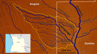
The Luanginga catchment area |
||
| Data | ||
| location |
|
|
| River system | Zambezi | |
| Drain over | Zambezi → Strait of Mozambique | |
| source | on the central plateau of the province of Moxico in Angola 13 ° 9 ′ 31 ″ S , 19 ° 39 ′ 47 ″ E |
|
| Source height | about 1450 m | |
| muzzle | at Mongu in the Zambezi Coordinates: 15 ° 11 ′ 29 " S , 22 ° 55 ′ 4" E 15 ° 11 ′ 29 " S , 22 ° 55 ′ 4" E |
|
| Mouth height | 996 m | |
| Height difference | about 454 m | |
| Bottom slope | about 0.91 ‰ | |
| length | about 500 km | |
| Catchment area | 35,893 km² | |
| Outflow A Eo : 35,893 km² at the mouth |
MNQ MQ Mq MHQ |
13.3 m³ / s 69.4 m³ / s 1.9 l / (s km²) 228 m³ / s |
| Left tributaries | Luambinda | |
| Right tributaries | Lucula , Mussuma , Northern Lueti | |
| Small towns | Calabo | |
| Residents in the catchment area | 122,000 (as of 2005-06) | |
The Luanginga is a right tributary of Sambesi which in Angola springs and Mongu in the West Province in Zambia opens.
course
The Luanginga is about 500 kilometers long. It rises on the central plateau of the Moxico province in Angola. Its valley is a wide floodplain with a decreasing slope. The section between Kalabo and Mongu has been canalized so that a boat can pass easily.
The Luanginga forms the southern border to the Liuwa Plain National Park . Kalabo is the official gateway to them.
Hydrometry
The flow rate of the catchment area of the river was measured in m³ / s.

Individual evidence
- ^ Soviet General Staff Map , accessed on October 6, 2012 at http://www.topomapper.com
- ↑ a b The Zambezi River Basin - A Multi-Sector Investment Opportunities Analysis - Volume 4 Modeling, Analysis and Input Data
- ^ A b The Zambezi River Basin - A Multi-Sector Investment Opportunities Analysis - Volume 3 State of the Basin

