Ludon (Midou)
| Ludon | ||
|
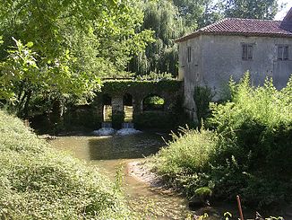
The river in the Pujo-le-Plan area |
||
| Data | ||
| Water code | FR : Q21-0400 | |
| location | France , Occitania and Nouvelle-Aquitaine regions | |
| River system | Adour | |
| Drain over | Midou → Midouze → Adour → Atlantic Ocean | |
| source | in the municipality of Le Houga, 43 ° 47 ′ 13 ″ N , 0 ° 11 ′ 53 ″ W |
|
| Source height | approx. 110 m | |
| muzzle | in the municipality of Bougue in the Midou coordinates: 43 ° 53 ′ 43 " N , 0 ° 23 ′ 23" W 43 ° 53 ′ 43 " N , 0 ° 23 ′ 23" W |
|
| Mouth height | approx. 40 m | |
| Height difference | approx. 70 m | |
| Bottom slope | approx. 2.7 ‰ | |
| length | 26 km | |
The Ludon is a river in France that runs through the Occitania and Nouvelle-Aquitaine regions. It rises in the municipality of Le Houga , generally drains in a north-westerly direction, is dammed up several times to form small lakes and, after 26 kilometers, flows into the Midou as a left tributary in the municipality of Bougue . On its way, the Ludon crosses the Gers and Landes departments .
Places on the river
(Order in flow direction)
Web links
Commons : Ludon - collection of images, videos and audio files
Individual evidence
- ↑ Source geoportail.gouv.fr
- ↑ estuary geoportail.gouv.fr
- ↑ a b The information on the river length is based on the information about the Ludon at SANDRE (French), accessed on July 31, 2013, rounded to full kilometers.
