
Palmachim Air Force Base
| Palmachim Airbase 30 & Spaceport, location in Israel: |
|||
|---|---|---|---|
|
|||
| Characteristics | |||
| ICAO code | LL59 | ||
| Coordinates | |||
| Height above MSL | 10 m (33 ft ) | ||
| Basic data | |||
| opening | 1970s | ||
| operator |
Israeli Air Force & Israel Space Agency |
||
| Runways | |||
| 03/21 | 2403 m asphalt | ||
| 13/31 | 803 m asphalt | ||

The Air Force Base Palmachim (English: Israeli Air Force Base Palmachim , ICAO code: LL59 ) consists of a military airfield of the Israeli Air Force (IAF) and a rocket launch site operated jointly by the Air Force and the Israel Space Agency (ISA). The airfield and rocket launch site are located directly on the Mediterranean Sea , south of Kibbutz Palmachim . The Tel Aviv-Jaffa metropolitan area begins about 12 km further north . The airfield has a longer and a shorter runway. The rocket launch site is here: ⊙ .
history
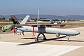
The airfield was laid out in the 1970s and the area was initially used to test missiles and projectiles that were fired towards the sea. A helicopter base was added later, and two squadrons of UH-60 Black Hawk were stationed there in 2020 . The testing and introduction of the IAI Heron 1 drone began in the mid-1990s , shortly afterwards the Elbit Hermes 450 and finally from 2009 its successor, the Hermes 900 , each with its own squadrons.
Rockets and space travel
With the launch of the Ofeq 1 satellite from Palmachim on September 19, 1988, the space age began for Israel. A newer satellite version was first launched on September 13, 2016 as Ofeq 11. The satellites are brought into orbit with the Shavit rocket and are mainly used for military reconnaissance .
The nuclear-armed Jericho missiles have also been tested here, although there are no official statements on this. On January 17, 2008, Israel tested a multi-stage ballistic missile here that is believed to be a Jericho III missile capable of carrying nuclear warheads several thousand kilometers. On November 2, 2011, Israel successfully tested again a presumably improved version of the Jericho III, whose long column of smoke could be seen throughout central Israel.
Due to Israel's geographic location and hostile relations with neighboring countries, the missiles are launched westward across the Mediterranean. This avoids flying over enemy countries and prevents parts from falling onto populated areas in the event of a crash. The launched satellites are in non-equatorial orbits and are among the few earth satellites that orbit the earth in an east-west direction. The start against the earth's rotation causes an approx. 30% higher fuel consumption.
Others
The Sorek nuclear research center has been located directly to the east of the airfield since 1960. It houses a research reactor , a cyclotron and a linear accelerator on its premises .
units
- 123rd Squadron UH-60L Black Hawk Yanshuf transport helicopter ("Desert Birds" Squadron)
- 124th Squadron UH-60L Black Hawk S-70A Yanshuf Rescue Helicopter ("Rolling Sword" Squadron)
- 161st Squadron Hermes 450 Zik drones ("Black Snake" Squadron)
- 166th Squadron Hermes 900 drones ("Spark" Squadron)
- 200th Squadron Heron 1 Shoval drones ("First UAV" Squadron)
- 151st Missile Test Squadron
- Helicopter and drone simulator squadron
- UAV training school (from 2004)

Newly built drone hangars in 2010 at Palmachim Air Base

UH-60 Black Hawk on Independence Day, based on Palmachim

Heron 1 drone (gray), Israel. Exhibition stationed on Palmachim
Hermes 450 drone on Independence Day, stationed on Palmachim
Hermes 900 drone at an exhibition, stationed on Palmachim

Test of an Arrow 2 rocket on the rocket launch site in 1996


Web links
Individual evidence
- ↑ https://www.globalsecurity.org/military/world/israel/palmachim.htm
- ↑ Yuval Azoulay: Missile test 'will improve deterrence' . In: Haaretz , January 18, 2008. Retrieved January 5, 2012.
- ↑ Anshel Pfeffer: IDF test-fires ballistic missile in central Israel . In: Haaretz , November 2, 2011. Retrieved November 3, 2011.
- ^ IAF website: The Rolling Sword Squadron
- ^ IAF website: The First UAV Squadron
