M2 motorway (Ireland)
| M2 motorway in Ireland | ||||||||||||||||||||||

|
||||||||||||||||||||||
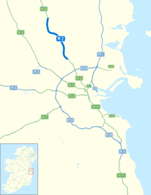
| map | ||||||||||||||||||||||
| Basic data | ||||||||||||||||||||||
| Operator: | Transport Infrastructure Ireland | |||||||||||||||||||||
| Start of the street: | M50 motorway (Ireland) Junction 5 | |||||||||||||||||||||
| End of street: | Ashbourne | |||||||||||||||||||||
| Overall length: | 12.5 km | |||||||||||||||||||||
|
Counties : |
||||||||||||||||||||||
| Beginning of the M2 at Ashbourne | ||||||||||||||||||||||
|
Course of the road
|
||||||||||||||||||||||
The M2 motorway ( English for "Autobahn M2", Irish Mótarbhealach M2 ) is a 12.5 km long, non-toll high-level road link in the Republic of Ireland , the one from the M50 motorway in Dublin via a 4.1 km long link to the N2 national road Leads north-northwest towards Ardee and Carrickmacross ; the N2 continues in Ireland to Monaghan and then crosses the border with Northern Ireland.
Individual evidence
- ↑ Ordnance Survey Ireland / Ordnance Survey Northern Ireland (Ed.): Official Road Atlas Ireland / Atlas oifigiúil Bóitre Éireann, 7th Edition 2018, ISBN 978-1-908852-83-0


