M50 motorway (Ireland)
| M50 motorway in Ireland | |||||||||||||||||||||||||||||||||||||||||||||||||||||||||||||

|
|||||||||||||||||||||||||||||||||||||||||||||||||||||||||||||
| |
|||||||||||||||||||||||||||||||||||||||||||||||||||||||||||||
| map | |||||||||||||||||||||||||||||||||||||||||||||||||||||||||||||
| Basic data | |||||||||||||||||||||||||||||||||||||||||||||||||||||||||||||
| Operator: | National Roads Authority | ||||||||||||||||||||||||||||||||||||||||||||||||||||||||||||
| Overall length: | 45 km | ||||||||||||||||||||||||||||||||||||||||||||||||||||||||||||
|
Counties : |
|||||||||||||||||||||||||||||||||||||||||||||||||||||||||||||
|
Course of the road
|
|||||||||||||||||||||||||||||||||||||||||||||||||||||||||||||
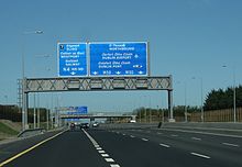
The M50 motorway ( Irish mótarbhealaí ) is an Irish motorway that forms the C-shaped motorway ring around Dublin . In the north the route ends at the entrance to the Dublin Port Tunnel , the south end is at the cross with the M11 . It is part of Europastrasse 1 .
history
The construction of the motorway was first considered in 1971 and then submitted to the national transport committee. Construction of the first section, the Western Parkway, began in 1987. The section between Junction 6 (Blanchardstown) and 11 (Tallaght) was opened to traffic in 1990. This was followed in 1996 by the Northern Cross section between junctions 3 (M1) and 6, before the opening of the section between exits 11 and 13 (Dundrum) in 2001.
The entire M50 motorway was opened on June 30, 2005, before the Dublin Port Tunnel was opened to traffic on December 20, 2006.
The renovation of the M50 began in spring 2006. Many of the roundabouts were then replaced by junction-free exits, so that traffic can flow more smoothly and there are fewer traffic jams. In addition, the motorway between the junction with the M1 and exit 13 Sandyford was expanded to six lanes. The M50 was then fully completed on Sunday, February 7th, 2010.
course
In an anti-clockwise direction, the M50 begins at the entrance to the Dublin Port Tunnel (toll road) and runs through the tunnel to the north, before turning west at the junction with the M1 . In the further course it crosses the Liffey over the West-Link toll bridge. At the south-east end of Dublin the M50 merges with the M11.
Every national road that runs from Dublin has a slip road to the M50, which is usually in the shape of a roundabout (above or below the carriageway). Furthermore, important suburbs (e.g. Ballymun , Tallaght , Dundrum or Sandyford ) are connected with their own driveways by the M50.
There are 17 driveways; but no eighth driveway - this was originally reserved for an extension of the M7 motorway between Lucan and Clondalkin . However, it is unlikely that this route will be realized.
East bypass
There are also plans to start an east bypass of Dublin. This proposal is controversial, however, because a tunnel would have to be built from Ringsend under the beach of Sandymount to (or even through the) Booterstown Marsh bird sanctuary . The Dublin port tunnel forms the northern part of the east bypass. It opened on December 20, 2006 and is toll-free for buses and trucks. The project, originally estimated at 450 million euros, ultimately cost around 750 million euros. The 4.5 km long tunnel is intended to keep trucks out of the inner city area, but vehicles with a height of more than 4.65 meters do not fit into the tunnel and have to drive on East Wall Road . The east bypass is to reunite with the M50 at Sandyford - the necessary building site for the motorway junction was already taken into account when planning the western M50 and the route from the western M50 to the N11 at Booterstown was kept free in the zoning plan.
See also
Web links
- Homepage of the M50. Archived from the original on January 3, 2010 ; accessed on May 14, 2017 .

